You are here: Home > Network List > TA - USArray Transportable Network (new EarthScope stations) Stations List
> Station W39A Magazine, AR, USA > Earthquake Result Viewer
W39A Magazine, AR, USA - Earthquake Result Viewer

| Earthquake location: |
Kuril Islands |
| Earthquake latitude/longitude: |
46.2/150.8 |
| Earthquake time(UTC): |
2013/04/19 (109) 03:05:52 GMT |
| Earthquake Depth: |
110 km |
| Earthquake Magnitude: |
7.2 MW, 7.1 MB, 7.2 MW |
| Earthquake Catalog/Contributor: |
NEIC PDE/NEIC PDE-W |
|
| Network: |
TA USArray Transportable Network (new EarthScope stations) |
| Station: |
W39A Magazine, AR, USA |
| Lat/Lon: |
35.20 N/93.78 W |
| Elevation: |
162 m |
|
| Distance: |
80.3 deg |
| Az: |
48.628 deg |
| Baz: |
320.493 deg |
| Ray Param: |
0.048136413 |
| Estimated Moho Depth: |
19.25 km |
| Estimated Crust Vp/Vs: |
1.97 |
| Assumed Crust Vp: |
6.498 km/s |
| Estimated Crust Vs: |
3.307 km/s |
| Estimated Crust Poisson's Ratio: |
0.33 |
|
| Radial Match: |
95.1099 % |
| Radial Bump: |
364 |
| Transverse Match: |
89.819 % |
| Transverse Bump: |
400 |
| SOD ConfigId: |
512894 |
| Insert Time: |
2013-09-13 11:51:27.529 +0000 |
| GWidth: |
2.5 |
| Max Bumps: |
400 |
| Tol: |
0.001 |
|
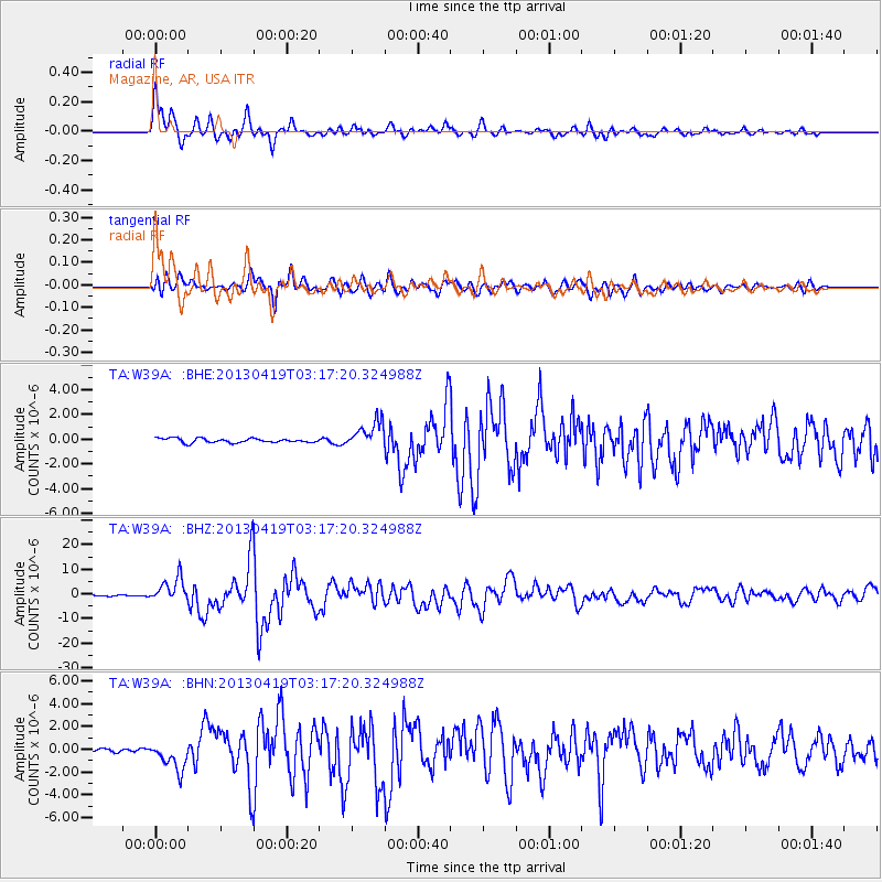
Signal To Noise
| Channel | StoN | STA | LTA |
| TA:W39A: :BHZ:20130419T03:17:20.324988Z | 23.360672 | 4.8426145E-6 | 2.0729775E-7 |
| TA:W39A: :BHN:20130419T03:17:20.324988Z | 7.5350704 | 1.2537364E-6 | 1.6638683E-7 |
| TA:W39A: :BHE:20130419T03:17:20.324988Z | 6.270731 | 1.0775059E-6 | 1.7183099E-7 |
| Arrivals |
| Ps | 2.9 SECOND |
| PpPs | 8.6 SECOND |
| PsPs/PpSs | 11 SECOND |


