You are here: Home > Network List > TA - USArray Transportable Network (new EarthScope stations) Stations List
> Station W49A Belvidere, TN, USA > Earthquake Result Viewer
W49A Belvidere, TN, USA - Earthquake Result Viewer
| Earthquake location: |
Kuril Islands |
| Earthquake latitude/longitude: |
46.2/150.8 |
| Earthquake time(UTC): |
2013/04/19 (109) 03:05:52 GMT |
| Earthquake Depth: |
110 km |
| Earthquake Magnitude: |
7.2 MW, 7.1 MB, 7.2 MW |
| Earthquake Catalog/Contributor: |
NEIC PDE/NEIC PDE-W |
|
| Network: |
TA USArray Transportable Network (new EarthScope stations) |
| Station: |
W49A Belvidere, TN, USA |
| Lat/Lon: |
35.12 N/86.26 W |
| Elevation: |
251 m |
|
| Distance: |
84.1 deg |
| Az: |
43.755 deg |
| Baz: |
324.146 deg |
| Ray Param: |
0.045475304 |
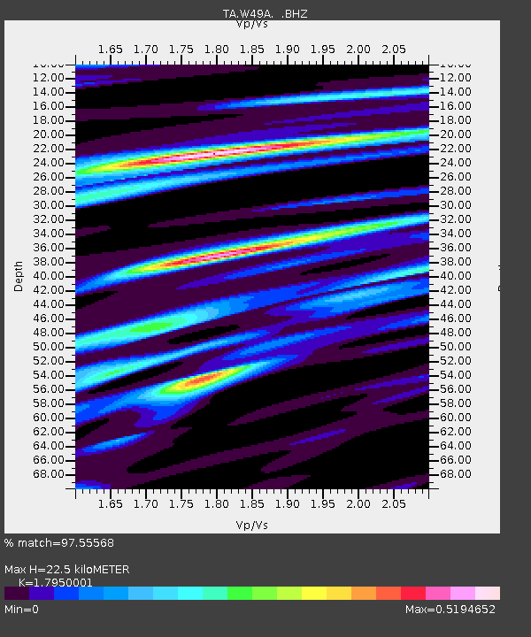
| Estimated Moho Depth: |
22.5 km |
| Estimated Crust Vp/Vs: |
1.80 |
| Assumed Crust Vp: |
6.476 km/s |
| Estimated Crust Vs: |
3.608 km/s |
| Estimated Crust Poisson's Ratio: |
0.27 |
|
| Radial Match: |
97.55568 % |
| Radial Bump: |
370 |
| Transverse Match: |
93.54055 % |
| Transverse Bump: |
400 |
| SOD ConfigId: |
512894 |
| Insert Time: |
2013-09-13 11:51:42.992 +0000 |
| GWidth: |
2.5 |
| Max Bumps: |
400 |
| Tol: |
0.001 |
|

Signal To Noise
| Channel | StoN | STA | LTA |
| TA:W49A: :BHZ:20130419T03:17:40.173987Z | 46.885944 | 5.3084937E-6 | 1.13221425E-7 |
| TA:W49A: :BHN:20130419T03:17:40.173987Z | 14.88624 | 1.3671753E-6 | 9.184154E-8 |
| TA:W49A: :BHE:20130419T03:17:40.173987Z | 5.231627 | 7.5817246E-7 | 1.4492097E-7 |
| Arrivals |
| Ps | 2.8 SECOND |
| PpPs | 9.5 SECOND |
| PsPs/PpSs | 12 SECOND |


