You are here: Home > Network List > TA - USArray Transportable Network (new EarthScope stations) Stations List
> Station W56A Indian Trail, NC, USA > Earthquake Result Viewer
W56A Indian Trail, NC, USA - Earthquake Result Viewer

| Earthquake location: |
Kuril Islands |
| Earthquake latitude/longitude: |
46.2/150.8 |
| Earthquake time(UTC): |
2013/04/19 (109) 03:05:52 GMT |
| Earthquake Depth: |
110 km |
| Earthquake Magnitude: |
7.2 MW, 7.1 MB, 7.2 MW |
| Earthquake Catalog/Contributor: |
NEIC PDE/NEIC PDE-W |
|
| Network: |
TA USArray Transportable Network (new EarthScope stations) |
| Station: |
W56A Indian Trail, NC, USA |
| Lat/Lon: |
35.13 N/80.58 W |
| Elevation: |
177 m |
|
| Distance: |
86.7 deg |
| Az: |
39.891 deg |
| Baz: |
327.093 deg |
| Ray Param: |
0.043604042 |
| Estimated Moho Depth: |
36.25 km |
| Estimated Crust Vp/Vs: |
1.74 |
| Assumed Crust Vp: |
6.419 km/s |
| Estimated Crust Vs: |
3.689 km/s |
| Estimated Crust Poisson's Ratio: |
0.25 |
|
| Radial Match: |
96.89564 % |
| Radial Bump: |
400 |
| Transverse Match: |
91.83425 % |
| Transverse Bump: |
400 |
| SOD ConfigId: |
512894 |
| Insert Time: |
2013-09-13 11:52:03.877 +0000 |
| GWidth: |
2.5 |
| Max Bumps: |
400 |
| Tol: |
0.001 |
|
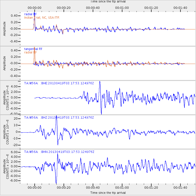
Signal To Noise
| Channel | StoN | STA | LTA |
| TA:W56A: :BHZ:20130419T03:17:53.124976Z | 31.2601 | 3.97141E-6 | 1.2704407E-7 |
| TA:W56A: :BHN:20130419T03:17:53.124976Z | 15.53934 | 1.1793963E-6 | 7.589746E-8 |
| TA:W56A: :BHE:20130419T03:17:53.124976Z | 8.259647 | 8.507668E-7 | 1.03002805E-7 |
| Arrivals |
| Ps | 4.3 SECOND |
| PpPs | 15 SECOND |
| PsPs/PpSs | 19 SECOND |


