You are here: Home > Network List > TA - USArray Transportable Network (new EarthScope stations) Stations List
> Station Y48A Jasper, AL, USA > Earthquake Result Viewer
Y48A Jasper, AL, USA - Earthquake Result Viewer
| Earthquake location: |
Kuril Islands |
| Earthquake latitude/longitude: |
46.2/150.8 |
| Earthquake time(UTC): |
2013/04/19 (109) 03:05:52 GMT |
| Earthquake Depth: |
110 km |
| Earthquake Magnitude: |
7.2 MW, 7.1 MB, 7.2 MW |
| Earthquake Catalog/Contributor: |
NEIC PDE/NEIC PDE-W |
|
| Network: |
TA USArray Transportable Network (new EarthScope stations) |
| Station: |
Y48A Jasper, AL, USA |
| Lat/Lon: |
33.91 N/87.17 W |
| Elevation: |
170 m |
|
| Distance: |
84.6 deg |
| Az: |
45.074 deg |
| Baz: |
323.764 deg |
| Ray Param: |
0.045094263 |
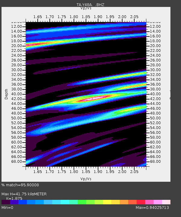
| Estimated Moho Depth: |
41.75 km |
| Estimated Crust Vp/Vs: |
1.88 |
| Assumed Crust Vp: |
6.565 km/s |
| Estimated Crust Vs: |
3.501 km/s |
| Estimated Crust Poisson's Ratio: |
0.30 |
|
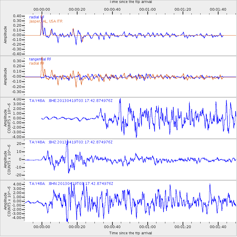
| Radial Match: |
95.90008 % |
| Radial Bump: |
400 |
| Transverse Match: |
83.864975 % |
| Transverse Bump: |
400 |
| SOD ConfigId: |
512894 |
| Insert Time: |
2013-09-13 11:53:34.926 +0000 |
| GWidth: |
2.5 |
| Max Bumps: |
400 |
| Tol: |
0.001 |
|
Signal To Noise
| Channel | StoN | STA | LTA |
| TA:Y48A: :BHZ:20130419T03:17:42.874976Z | 28.543392 | 4.052106E-6 | 1.4196301E-7 |
| TA:Y48A: :BHN:20130419T03:17:42.874976Z | 5.35194 | 1.2329831E-6 | 2.3038058E-7 |
| TA:Y48A: :BHE:20130419T03:17:42.874976Z | 4.0538745 | 7.545459E-7 | 1.8612957E-7 |
| Arrivals |
| Ps | 5.7 SECOND |
| PpPs | 18 SECOND |
| PsPs/PpSs | 24 SECOND |


