You are here: Home > Network List > TA - USArray Transportable Network (new EarthScope stations) Stations List
> Station Y54A Tignall, GA, USA > Earthquake Result Viewer
Y54A Tignall, GA, USA - Earthquake Result Viewer
| Earthquake location: |
Kuril Islands |
| Earthquake latitude/longitude: |
46.2/150.8 |
| Earthquake time(UTC): |
2013/04/19 (109) 03:05:52 GMT |
| Earthquake Depth: |
110 km |
| Earthquake Magnitude: |
7.2 MW, 7.1 MB, 7.2 MW |
| Earthquake Catalog/Contributor: |
NEIC PDE/NEIC PDE-W |
|
| Network: |
TA USArray Transportable Network (new EarthScope stations) |
| Station: |
Y54A Tignall, GA, USA |
| Lat/Lon: |
33.86 N/82.69 W |
| Elevation: |
176 m |
|
| Distance: |
86.8 deg |
| Az: |
42.045 deg |
| Baz: |
326.027 deg |
| Ray Param: |
0.043530207 |
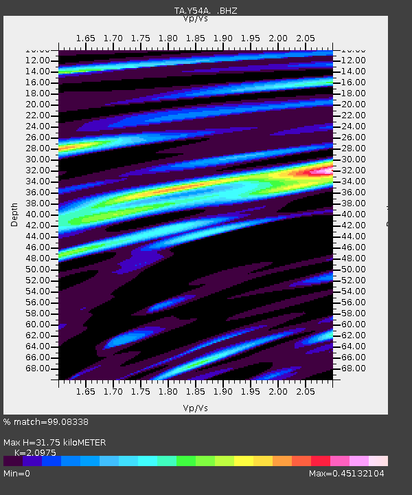
| Estimated Moho Depth: |
31.75 km |
| Estimated Crust Vp/Vs: |
2.10 |
| Assumed Crust Vp: |
6.565 km/s |
| Estimated Crust Vs: |
3.13 km/s |
| Estimated Crust Poisson's Ratio: |
0.35 |
|
| Radial Match: |
99.08338 % |
| Radial Bump: |
243 |
| Transverse Match: |
96.58557 % |
| Transverse Bump: |
400 |
| SOD ConfigId: |
512894 |
| Insert Time: |
2013-09-13 11:53:51.791 +0000 |
| GWidth: |
2.5 |
| Max Bumps: |
400 |
| Tol: |
0.001 |
|

Signal To Noise
| Channel | StoN | STA | LTA |
| TA:Y54A: :BHZ:20130419T03:17:53.624976Z | 62.873966 | 6.7837527E-6 | 1.07894465E-7 |
| TA:Y54A: :BHN:20130419T03:17:53.624976Z | 25.000181 | 2.1509752E-6 | 8.603838E-8 |
| TA:Y54A: :BHE:20130419T03:17:53.624976Z | 17.466124 | 1.779684E-6 | 1.0189348E-7 |
| Arrivals |
| Ps | 5.4 SECOND |
| PpPs | 15 SECOND |
| PsPs/PpSs | 20 SECOND |


