You are here: Home > Network List > TA - USArray Transportable Network (new EarthScope stations) Stations List
> Station Y60A Bolivia, NC, USA > Earthquake Result Viewer
Y60A Bolivia, NC, USA - Earthquake Result Viewer
| Earthquake location: |
Kuril Islands |
| Earthquake latitude/longitude: |
46.2/150.8 |
| Earthquake time(UTC): |
2013/04/19 (109) 03:05:52 GMT |
| Earthquake Depth: |
110 km |
| Earthquake Magnitude: |
7.2 MW, 7.1 MB, 7.2 MW |
| Earthquake Catalog/Contributor: |
NEIC PDE/NEIC PDE-W |
|
| Network: |
TA USArray Transportable Network (new EarthScope stations) |
| Station: |
Y60A Bolivia, NC, USA |
| Lat/Lon: |
34.00 N/78.22 W |
| Elevation: |
7.0 m |
|
| Distance: |
88.7 deg |
| Az: |
38.841 deg |
| Baz: |
328.388 deg |
| Ray Param: |
0.04214424 |
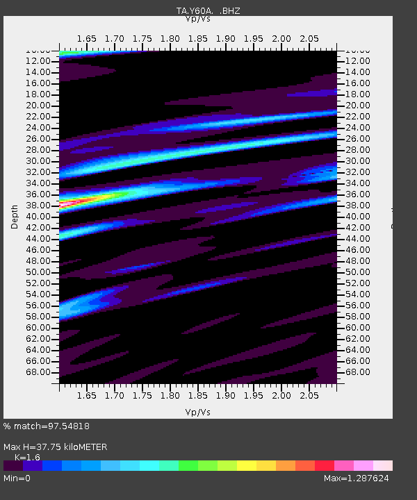
| Estimated Moho Depth: |
37.75 km |
| Estimated Crust Vp/Vs: |
1.60 |
| Assumed Crust Vp: |
6.565 km/s |
| Estimated Crust Vs: |
4.103 km/s |
| Estimated Crust Poisson's Ratio: |
0.18 |
|
| Radial Match: |
97.54818 % |
| Radial Bump: |
352 |
| Transverse Match: |
96.278824 % |
| Transverse Bump: |
324 |
| SOD ConfigId: |
512894 |
| Insert Time: |
2013-09-13 11:54:11.479 +0000 |
| GWidth: |
2.5 |
| Max Bumps: |
400 |
| Tol: |
0.001 |
|

Signal To Noise
| Channel | StoN | STA | LTA |
| TA:Y60A: :BHZ:20130419T03:18:02.624976Z | 19.902502 | 5.463258E-6 | 2.7450105E-7 |
| TA:Y60A: :BHN:20130419T03:18:02.624976Z | 3.0417776 | 1.4717372E-6 | 4.838412E-7 |
| TA:Y60A: :BHE:20130419T03:18:02.624976Z | 3.2814455 | 1.5299646E-6 | 4.6624717E-7 |
| Arrivals |
| Ps | 3.5 SECOND |
| PpPs | 15 SECOND |
| PsPs/PpSs | 18 SECOND |


