You are here: Home > Network List > TA - USArray Transportable Network (new EarthScope stations) Stations List
> Station Z52A Williamson, GA, USA > Earthquake Result Viewer
Z52A Williamson, GA, USA - Earthquake Result Viewer
| Earthquake location: |
Kuril Islands |
| Earthquake latitude/longitude: |
46.2/150.8 |
| Earthquake time(UTC): |
2013/04/19 (109) 03:05:52 GMT |
| Earthquake Depth: |
110 km |
| Earthquake Magnitude: |
7.2 MW, 7.1 MB, 7.2 MW |
| Earthquake Catalog/Contributor: |
NEIC PDE/NEIC PDE-W |
|
| Network: |
TA USArray Transportable Network (new EarthScope stations) |
| Station: |
Z52A Williamson, GA, USA |
| Lat/Lon: |
33.19 N/84.42 W |
| Elevation: |
252 m |
|
| Distance: |
86.6 deg |
| Az: |
43.619 deg |
| Baz: |
325.167 deg |
| Ray Param: |
0.043721594 |
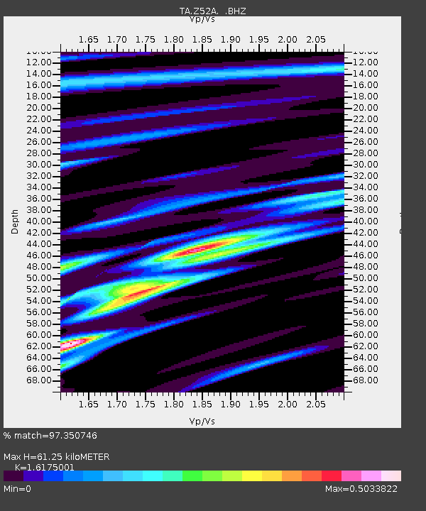
| Estimated Moho Depth: |
61.25 km |
| Estimated Crust Vp/Vs: |
1.62 |
| Assumed Crust Vp: |
6.719 km/s |
| Estimated Crust Vs: |
4.154 km/s |
| Estimated Crust Poisson's Ratio: |
0.19 |
|
| Radial Match: |
97.350746 % |
| Radial Bump: |
301 |
| Transverse Match: |
92.03999 % |
| Transverse Bump: |
400 |
| SOD ConfigId: |
512894 |
| Insert Time: |
2013-09-13 11:54:25.615 +0000 |
| GWidth: |
2.5 |
| Max Bumps: |
400 |
| Tol: |
0.001 |
|
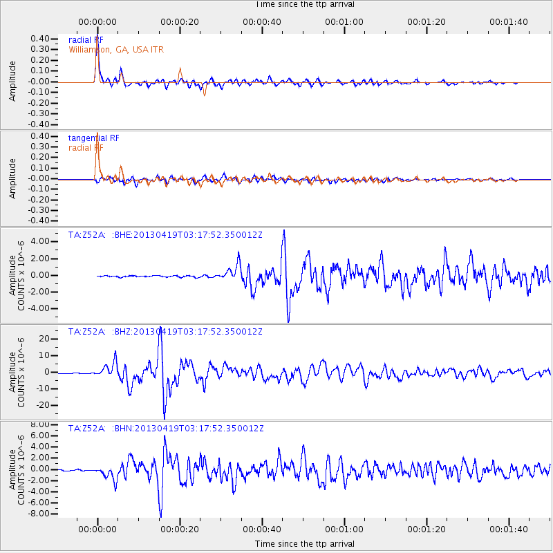
Signal To Noise
| Channel | StoN | STA | LTA |
| TA:Z52A: :BHZ:20130419T03:17:52.350012Z | 25.630129 | 4.638091E-6 | 1.8096247E-7 |
| TA:Z52A: :BHN:20130419T03:17:52.350012Z | 9.208169 | 1.243105E-6 | 1.3500023E-7 |
| TA:Z52A: :BHE:20130419T03:17:52.350012Z | 11.829498 | 9.743087E-7 | 8.236264E-8 |
| Arrivals |
| Ps | 5.8 SECOND |
| PpPs | 23 SECOND |
| PsPs/PpSs | 29 SECOND |


