You are here: Home > Network List > TA - USArray Transportable Network (new EarthScope stations) Stations List
> Station Z53A Monticello, GA, USA > Earthquake Result Viewer
Z53A Monticello, GA, USA - Earthquake Result Viewer

| Earthquake location: |
Kuril Islands |
| Earthquake latitude/longitude: |
46.2/150.8 |
| Earthquake time(UTC): |
2013/04/19 (109) 03:05:52 GMT |
| Earthquake Depth: |
110 km |
| Earthquake Magnitude: |
7.2 MW, 7.1 MB, 7.2 MW |
| Earthquake Catalog/Contributor: |
NEIC PDE/NEIC PDE-W |
|
| Network: |
TA USArray Transportable Network (new EarthScope stations) |
| Station: |
Z53A Monticello, GA, USA |
| Lat/Lon: |
33.28 N/83.57 W |
| Elevation: |
144 m |
|
| Distance: |
86.9 deg |
| Az: |
42.982 deg |
| Baz: |
325.592 deg |
| Ray Param: |
0.04348233 |
| Estimated Moho Depth: |
41.0 km |
| Estimated Crust Vp/Vs: |
1.88 |
| Assumed Crust Vp: |
6.565 km/s |
| Estimated Crust Vs: |
3.501 km/s |
| Estimated Crust Poisson's Ratio: |
0.30 |
|
| Radial Match: |
96.98108 % |
| Radial Bump: |
329 |
| Transverse Match: |
92.332405 % |
| Transverse Bump: |
400 |
| SOD ConfigId: |
512894 |
| Insert Time: |
2013-09-13 11:54:29.396 +0000 |
| GWidth: |
2.5 |
| Max Bumps: |
400 |
| Tol: |
0.001 |
|
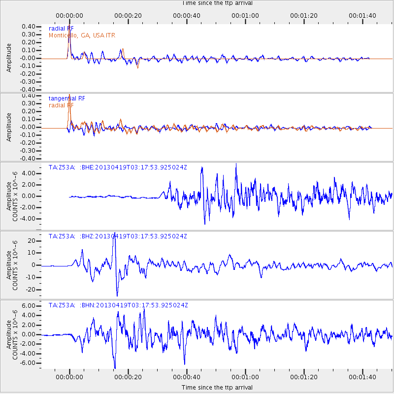
Signal To Noise
| Channel | StoN | STA | LTA |
| TA:Z53A: :BHZ:20130419T03:17:53.925024Z | 48.67902 | 4.464803E-6 | 9.1719244E-8 |
| TA:Z53A: :BHN:20130419T03:17:53.925024Z | 11.30824 | 1.1179679E-6 | 9.8863126E-8 |
| TA:Z53A: :BHE:20130419T03:17:53.925024Z | 7.1646366 | 8.10981E-7 | 1.131922E-7 |
| Arrivals |
| Ps | 5.6 SECOND |
| PpPs | 18 SECOND |
| PsPs/PpSs | 23 SECOND |


