You are here: Home > Network List > TA - USArray Transportable Network (new EarthScope stations) Stations List
> Station Z55A Blythe, GA, USA > Earthquake Result Viewer
Z55A Blythe, GA, USA - Earthquake Result Viewer
| Earthquake location: |
Kuril Islands |
| Earthquake latitude/longitude: |
46.2/150.8 |
| Earthquake time(UTC): |
2013/04/19 (109) 03:05:52 GMT |
| Earthquake Depth: |
110 km |
| Earthquake Magnitude: |
7.2 MW, 7.1 MB, 7.2 MW |
| Earthquake Catalog/Contributor: |
NEIC PDE/NEIC PDE-W |
|
| Network: |
TA USArray Transportable Network (new EarthScope stations) |
| Station: |
Z55A Blythe, GA, USA |
| Lat/Lon: |
33.22 N/82.14 W |
| Elevation: |
100 m |
|
| Distance: |
87.6 deg |
| Az: |
42.018 deg |
| Baz: |
326.33 deg |
| Ray Param: |
0.04296082 |
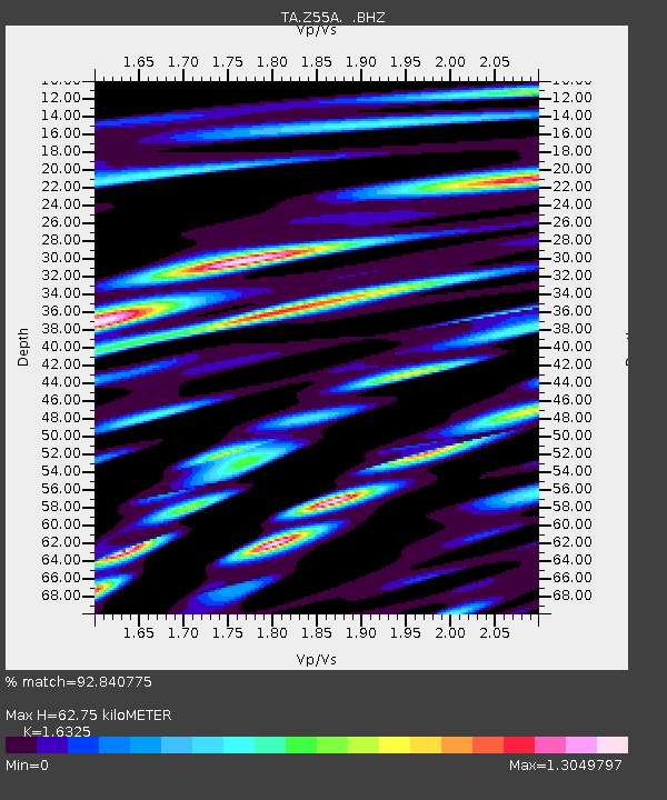
| Estimated Moho Depth: |
62.75 km |
| Estimated Crust Vp/Vs: |
1.63 |
| Assumed Crust Vp: |
6.565 km/s |
| Estimated Crust Vs: |
4.021 km/s |
| Estimated Crust Poisson's Ratio: |
0.20 |
|
| Radial Match: |
92.840775 % |
| Radial Bump: |
400 |
| Transverse Match: |
84.00932 % |
| Transverse Bump: |
400 |
| SOD ConfigId: |
512894 |
| Insert Time: |
2013-09-13 11:54:36.612 +0000 |
| GWidth: |
2.5 |
| Max Bumps: |
400 |
| Tol: |
0.001 |
|
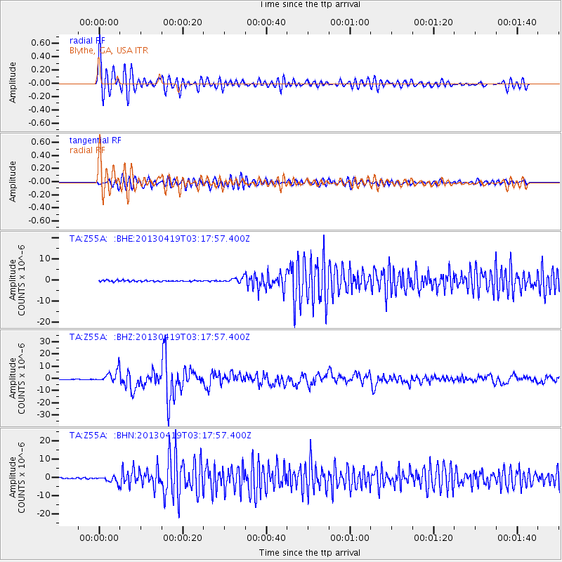
Signal To Noise
| Channel | StoN | STA | LTA |
| TA:Z55A: :BHZ:20130419T03:17:57.400Z | 29.491653 | 5.281113E-6 | 1.7907145E-7 |
| TA:Z55A: :BHN:20130419T03:17:57.400Z | 7.03874 | 1.7730808E-6 | 2.5190315E-7 |
| TA:Z55A: :BHE:20130419T03:17:57.400Z | 4.0038233 | 1.1329806E-6 | 2.8297467E-7 |
| Arrivals |
| Ps | 6.2 SECOND |
| PpPs | 25 SECOND |
| PsPs/PpSs | 31 SECOND |


