You are here: Home > Network List > TJ - Tajikistan National Seismic Network Stations List
> Station GARM Garm, Tajikistan > Earthquake Result Viewer
GARM Garm, Tajikistan - Earthquake Result Viewer
| Earthquake location: |
Kuril Islands |
| Earthquake latitude/longitude: |
46.2/150.8 |
| Earthquake time(UTC): |
2013/04/19 (109) 03:05:52 GMT |
| Earthquake Depth: |
110 km |
| Earthquake Magnitude: |
7.2 MW, 7.1 MB, 7.2 MW |
| Earthquake Catalog/Contributor: |
NEIC PDE/NEIC PDE-W |
|
| Network: |
TJ Tajikistan National Seismic Network |
| Station: |
GARM Garm, Tajikistan |
| Lat/Lon: |
39.00 N/70.32 E |
| Elevation: |
1305 m |
|
| Distance: |
57.3 deg |
| Az: |
294.012 deg |
| Baz: |
54.481 deg |
| Ray Param: |
0.06327256 |
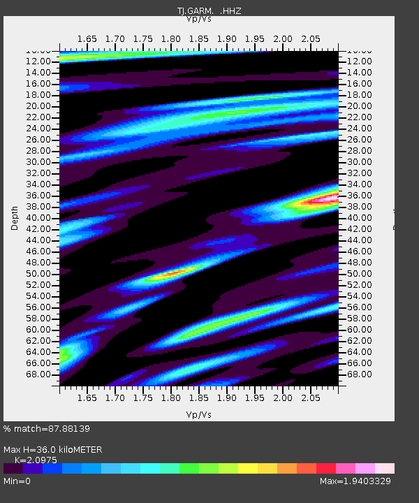
| Estimated Moho Depth: |
36.0 km |
| Estimated Crust Vp/Vs: |
2.10 |
| Assumed Crust Vp: |
6.306 km/s |
| Estimated Crust Vs: |
3.006 km/s |
| Estimated Crust Poisson's Ratio: |
0.35 |
|
| Radial Match: |
87.88139 % |
| Radial Bump: |
400 |
| Transverse Match: |
87.111946 % |
| Transverse Bump: |
390 |
| SOD ConfigId: |
512894 |
| Insert Time: |
2013-09-13 11:54:55.394 +0000 |
| GWidth: |
2.5 |
| Max Bumps: |
400 |
| Tol: |
0.001 |
|

Signal To Noise
| Channel | StoN | STA | LTA |
| TJ:GARM: :HHZ:20130419T03:14:58.119971Z | 55.529037 | 1.0434316E-5 | 1.8790739E-7 |
| TJ:GARM: :HHN:20130419T03:14:58.119971Z | 9.697203 | 1.5595231E-6 | 1.6082195E-7 |
| TJ:GARM: :HHE:20130419T03:14:58.119971Z | 22.98199 | 3.5888822E-6 | 1.5616062E-7 |
| Arrivals |
| Ps | 6.5 SECOND |
| PpPs | 17 SECOND |
| PsPs/PpSs | 24 SECOND |


