You are here: Home > Network List > UO - University of Oregon Regional Network Stations List
> Station DBO Dodson Butte, OR (UO CREST BB SMO) > Earthquake Result Viewer
DBO Dodson Butte, OR (UO CREST BB SMO) - Earthquake Result Viewer
| Earthquake location: |
Kuril Islands |
| Earthquake latitude/longitude: |
46.2/150.8 |
| Earthquake time(UTC): |
2013/04/19 (109) 03:05:52 GMT |
| Earthquake Depth: |
110 km |
| Earthquake Magnitude: |
7.2 MW, 7.1 MB, 7.2 MW |
| Earthquake Catalog/Contributor: |
NEIC PDE/NEIC PDE-W |
|
| Network: |
UO University of Oregon Regional Network |
| Station: |
DBO Dodson Butte, OR (UO CREST BB SMO) |
| Lat/Lon: |
43.12 N/123.24 W |
| Elevation: |
984 m |
|
| Distance: |
58.3 deg |
| Az: |
59.177 deg |
| Baz: |
305.484 deg |
| Ray Param: |
0.06262727 |
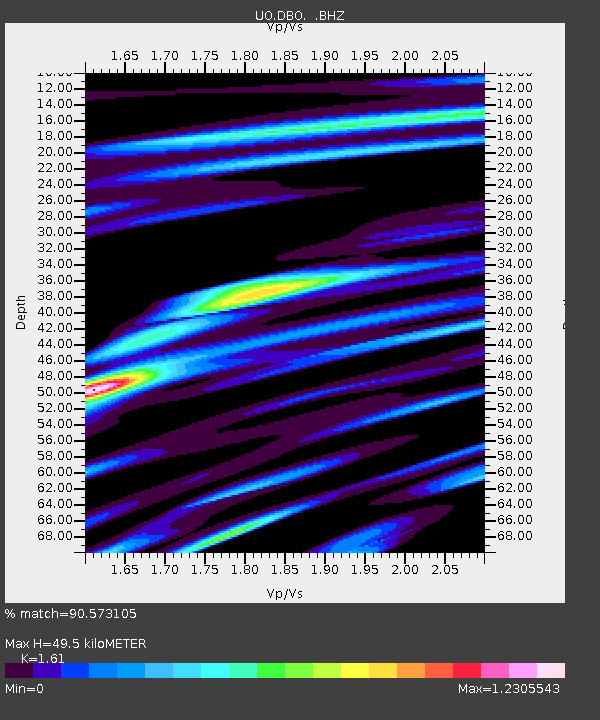
| Estimated Moho Depth: |
49.5 km |
| Estimated Crust Vp/Vs: |
1.61 |
| Assumed Crust Vp: |
6.522 km/s |
| Estimated Crust Vs: |
4.051 km/s |
| Estimated Crust Poisson's Ratio: |
0.19 |
|
| Radial Match: |
90.573105 % |
| Radial Bump: |
400 |
| Transverse Match: |
80.378105 % |
| Transverse Bump: |
400 |
| SOD ConfigId: |
512894 |
| Insert Time: |
2013-09-13 11:55:17.769 +0000 |
| GWidth: |
2.5 |
| Max Bumps: |
400 |
| Tol: |
0.001 |
|

Signal To Noise
| Channel | StoN | STA | LTA |
| UO:DBO: :BHZ:20130419T03:15:05.090002Z | 19.94523 | 3.064175E-6 | 1.5362946E-7 |
| UO:DBO: :BHN:20130419T03:15:05.090002Z | 4.9291906 | 6.3089874E-7 | 1.2799237E-7 |
| UO:DBO: :BHE:20130419T03:15:05.090002Z | 8.647593 | 1.1207587E-6 | 1.2960355E-7 |
| Arrivals |
| Ps | 4.9 SECOND |
| PpPs | 19 SECOND |
| PsPs/PpSs | 24 SECOND |


