You are here: Home > Network List > US - United States National Seismic Network Stations List
> Station DUG Dugway, Tooele County, Utah, USA > Earthquake Result Viewer
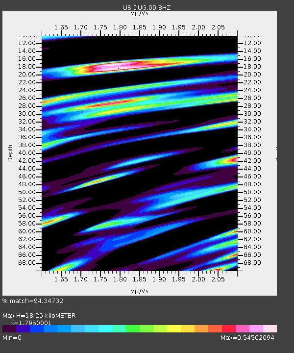
DUG Dugway, Tooele County, Utah, USA - Earthquake Result Viewer
| Earthquake location: |
Kuril Islands |
| Earthquake latitude/longitude: |
46.2/150.8 |
| Earthquake time(UTC): |
2013/04/19 (109) 03:05:52 GMT |
| Earthquake Depth: |
110 km |
| Earthquake Magnitude: |
7.2 MW, 7.1 MB, 7.2 MW |
| Earthquake Catalog/Contributor: |
NEIC PDE/NEIC PDE-W |
|
| Network: |
US United States National Seismic Network |
| Station: |
DUG Dugway, Tooele County, Utah, USA |
| Lat/Lon: |
40.19 N/112.81 W |
| Elevation: |
1477 m |
|
| Distance: |
66.2 deg |
| Az: |
56.294 deg |
| Baz: |
311.058 deg |
| Ray Param: |
0.05747077 |
| Estimated Moho Depth: |
18.25 km |
| Estimated Crust Vp/Vs: |
1.80 |
| Assumed Crust Vp: |
6.276 km/s |
| Estimated Crust Vs: |
3.496 km/s |
| Estimated Crust Poisson's Ratio: |
0.27 |
|
| Radial Match: |
94.34732 % |
| Radial Bump: |
400 |
| Transverse Match: |
91.58217 % |
| Transverse Bump: |
400 |
| SOD ConfigId: |
512894 |
| Insert Time: |
2013-09-13 11:56:05.926 +0000 |
| GWidth: |
2.5 |
| Max Bumps: |
400 |
| Tol: |
0.001 |
|

Signal To Noise
| Channel | StoN | STA | LTA |
| US:DUG:00:BHZ:20130419T03:15:57.899023Z | 46.856056 | 3.947568E-6 | 8.4248825E-8 |
| US:DUG:00:BH1:20130419T03:15:57.899023Z | 9.942085 | 1.2949548E-6 | 1.3024983E-7 |
| US:DUG:00:BH2:20130419T03:15:57.899023Z | 8.050751 | 1.1297354E-6 | 1.4032672E-7 |
| Arrivals |
| Ps | 2.4 SECOND |
| PpPs | 7.8 SECOND |
| PsPs/PpSs | 10 SECOND |


