You are here: Home > Network List > US - United States National Seismic Network Stations List
> Station NHSC New Hope, South Carolina, USA > Earthquake Result Viewer
NHSC New Hope, South Carolina, USA - Earthquake Result Viewer
| Earthquake location: |
Kuril Islands |
| Earthquake latitude/longitude: |
46.2/150.8 |
| Earthquake time(UTC): |
2013/04/19 (109) 03:05:52 GMT |
| Earthquake Depth: |
110 km |
| Earthquake Magnitude: |
7.2 MW, 7.1 MB, 7.2 MW |
| Earthquake Catalog/Contributor: |
NEIC PDE/NEIC PDE-W |
|
| Network: |
US United States National Seismic Network |
| Station: |
NHSC New Hope, South Carolina, USA |
| Lat/Lon: |
33.11 N/80.18 W |
| Elevation: |
11 m |
|
| Distance: |
88.6 deg |
| Az: |
40.704 deg |
| Baz: |
327.353 deg |
| Ray Param: |
0.042225998 |
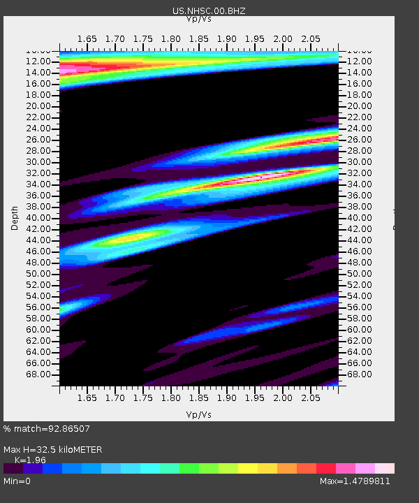
| Estimated Moho Depth: |
32.5 km |
| Estimated Crust Vp/Vs: |
1.96 |
| Assumed Crust Vp: |
6.565 km/s |
| Estimated Crust Vs: |
3.349 km/s |
| Estimated Crust Poisson's Ratio: |
0.32 |
|
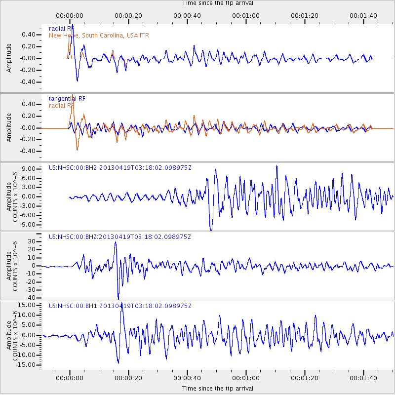
| Radial Match: |
92.86507 % |
| Radial Bump: |
333 |
| Transverse Match: |
91.46901 % |
| Transverse Bump: |
384 |
| SOD ConfigId: |
512894 |
| Insert Time: |
2013-09-13 11:57:20.214 +0000 |
| GWidth: |
2.5 |
| Max Bumps: |
400 |
| Tol: |
0.001 |
|
Signal To Noise
| Channel | StoN | STA | LTA |
| US:NHSC:00:BHZ:20130419T03:18:02.098975Z | 15.840491 | 4.777719E-6 | 3.016143E-7 |
| US:NHSC:00:BH1:20130419T03:18:02.098975Z | 2.5317855 | 1.126816E-6 | 4.4506774E-7 |
| US:NHSC:00:BH2:20130419T03:18:02.098975Z | 1.4200809 | 1.008747E-6 | 7.1034475E-7 |
| Arrivals |
| Ps | 4.8 SECOND |
| PpPs | 14 SECOND |
| PsPs/PpSs | 19 SECOND |


