You are here: Home > Network List > US - United States National Seismic Network Stations List
> Station VBMS Vicksburg, Mississippi > Earthquake Result Viewer
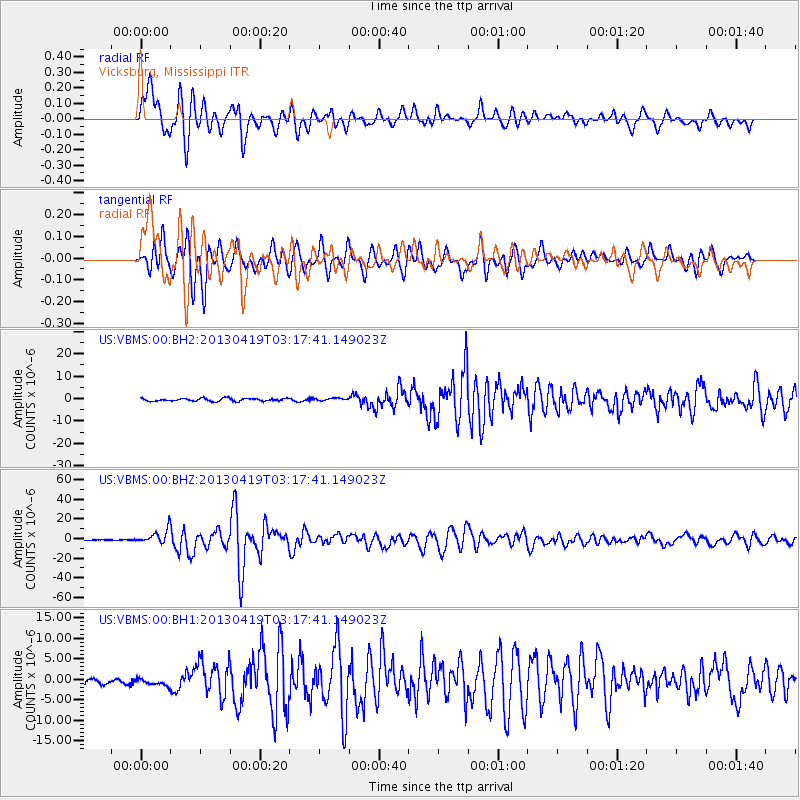
VBMS Vicksburg, Mississippi - Earthquake Result Viewer
*The percent match for this event was below the threshold and hence no stack was calculated.
| Earthquake location: |
Kuril Islands |
| Earthquake latitude/longitude: |
46.2/150.8 |
| Earthquake time(UTC): |
2013/04/19 (109) 03:05:52 GMT |
| Earthquake Depth: |
110 km |
| Earthquake Magnitude: |
7.2 MW, 7.1 MB, 7.2 MW |
| Earthquake Catalog/Contributor: |
NEIC PDE/NEIC PDE-W |
|
| Network: |
US United States National Seismic Network |
| Station: |
VBMS Vicksburg, Mississippi |
| Lat/Lon: |
32.22 N/90.52 W |
| Elevation: |
0.0 m |
|
| Distance: |
84.3 deg |
| Az: |
48.351 deg |
| Baz: |
322.262 deg |
| Ray Param: |
$rayparam |
*The percent match for this event was below the threshold and hence was not used in the summary stack. |
|
| Radial Match: |
92.74855 % |
| Radial Bump: |
400 |
| Transverse Match: |
88.6509 % |
| Transverse Bump: |
400 |
| SOD ConfigId: |
512894 |
| Insert Time: |
2013-09-13 11:57:49.155 +0000 |
| GWidth: |
2.5 |
| Max Bumps: |
400 |
| Tol: |
0.001 |
|
Signal To Noise
| Channel | StoN | STA | LTA |
| US:VBMS:00:BHZ:20130419T03:17:41.149023Z | 27.816563 | 7.1491695E-6 | 2.5701124E-7 |
| US:VBMS:00:BH1:20130419T03:17:41.149023Z | 1.0096005 | 9.873213E-7 | 9.779326E-7 |
| US:VBMS:00:BH2:20130419T03:17:41.149023Z | 0.95213884 | 5.886227E-7 | 6.1821095E-7 |
| Arrivals |
| Ps | |
| PpPs | |
| PsPs/PpSs | |


