You are here: Home > Network List > GO - National Seismic Network of Georgia Stations List
> Station TBLG Delisi, Georgia > Earthquake Result Viewer
TBLG Delisi, Georgia - Earthquake Result Viewer
| Earthquake location: |
South Of Timor, Indonesia |
| Earthquake latitude/longitude: |
-12.0/121.6 |
| Earthquake time(UTC): |
2013/04/19 (109) 17:51:41 GMT |
| Earthquake Depth: |
15 km |
| Earthquake Magnitude: |
5.8 MW, 5.7 MW, 6.0 MB |
| Earthquake Catalog/Contributor: |
NEIC PDE/NEIC PDE-W |
|
| Network: |
GO National Seismic Network of Georgia |
| Station: |
TBLG Delisi, Georgia |
| Lat/Lon: |
41.73 N/44.74 E |
| Elevation: |
510 m |
|
| Distance: |
88.3 deg |
| Az: |
313.171 deg |
| Baz: |
107.553 deg |
| Ray Param: |
0.042667165 |
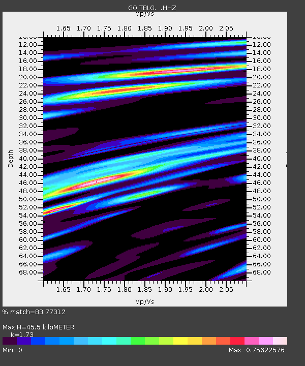
| Estimated Moho Depth: |
45.5 km |
| Estimated Crust Vp/Vs: |
1.73 |
| Assumed Crust Vp: |
6.291 km/s |
| Estimated Crust Vs: |
3.636 km/s |
| Estimated Crust Poisson's Ratio: |
0.25 |
|
| Radial Match: |
83.77312 % |
| Radial Bump: |
400 |
| Transverse Match: |
84.28208 % |
| Transverse Bump: |
400 |
| SOD ConfigId: |
512894 |
| Insert Time: |
2013-09-13 12:07:03.919 +0000 |
| GWidth: |
2.5 |
| Max Bumps: |
400 |
| Tol: |
0.001 |
|
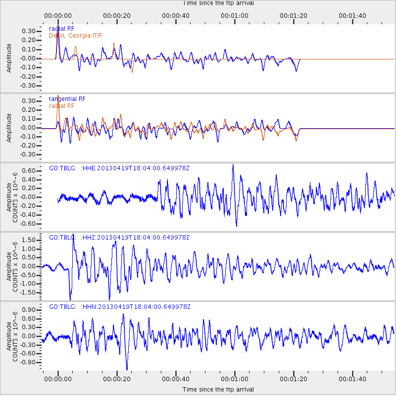
Signal To Noise
| Channel | StoN | STA | LTA |
| GO:TBLG: :HHZ:20130419T18:04:00.649978Z | 5.971731 | 6.087812E-7 | 1.0194384E-7 |
| GO:TBLG: :HHN:20130419T18:04:00.649978Z | 1.3270886 | 8.973974E-8 | 6.7621514E-8 |
| GO:TBLG: :HHE:20130419T18:04:00.649978Z | 2.194647 | 1.4110003E-7 | 6.429281E-8 |
| Arrivals |
| Ps | 5.4 SECOND |
| PpPs | 19 SECOND |
| PsPs/PpSs | 25 SECOND |


