You are here: Home > Network List > IU - Global Seismograph Network (GSN - IRIS/USGS) Stations List
> Station HNR Honiara, Solomon Islands > Earthquake Result Viewer
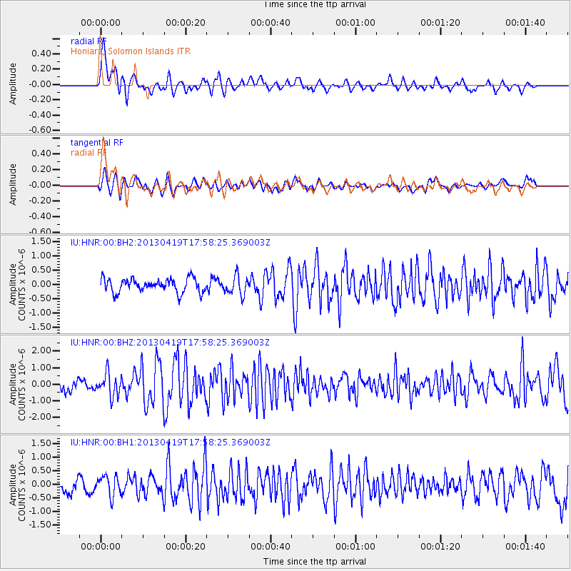
HNR Honiara, Solomon Islands - Earthquake Result Viewer
*The percent match for this event was below the threshold and hence no stack was calculated.
| Earthquake location: |
South Of Timor, Indonesia |
| Earthquake latitude/longitude: |
-12.0/121.6 |
| Earthquake time(UTC): |
2013/04/19 (109) 17:51:41 GMT |
| Earthquake Depth: |
15 km |
| Earthquake Magnitude: |
5.8 MW, 5.7 MW, 6.0 MB |
| Earthquake Catalog/Contributor: |
NEIC PDE/NEIC PDE-W |
|
| Network: |
IU Global Seismograph Network (GSN - IRIS/USGS) |
| Station: |
HNR Honiara, Solomon Islands |
| Lat/Lon: |
9.44 S/159.95 E |
| Elevation: |
100 m |
|
| Distance: |
37.7 deg |
| Az: |
89.983 deg |
| Baz: |
262.643 deg |
| Ray Param: |
$rayparam |
*The percent match for this event was below the threshold and hence was not used in the summary stack. |
|
| Radial Match: |
75.24181 % |
| Radial Bump: |
400 |
| Transverse Match: |
66.44666 % |
| Transverse Bump: |
400 |
| SOD ConfigId: |
512894 |
| Insert Time: |
2013-09-13 12:09:19.005 +0000 |
| GWidth: |
2.5 |
| Max Bumps: |
400 |
| Tol: |
0.001 |
|
Signal To Noise
| Channel | StoN | STA | LTA |
| IU:HNR:00:BHZ:20130419T17:58:25.369003Z | 2.130777 | 7.004063E-7 | 3.2870938E-7 |
| IU:HNR:00:BH1:20130419T17:58:25.369003Z | 1.8773514 | 3.8479E-7 | 2.049643E-7 |
| IU:HNR:00:BH2:20130419T17:58:25.369003Z | 1.3813668 | 3.301353E-7 | 2.3899176E-7 |
| Arrivals |
| Ps | |
| PpPs | |
| PsPs/PpSs | |


