You are here: Home > Network List > KR - Kyrgyz Digital Network Stations List
> Station ARSB Arslanbob, Kyrgyzstan > Earthquake Result Viewer
ARSB Arslanbob, Kyrgyzstan - Earthquake Result Viewer
| Earthquake location: |
South Of Timor, Indonesia |
| Earthquake latitude/longitude: |
-12.0/121.6 |
| Earthquake time(UTC): |
2013/04/19 (109) 17:51:41 GMT |
| Earthquake Depth: |
15 km |
| Earthquake Magnitude: |
5.8 MW, 5.7 MW, 6.0 MB |
| Earthquake Catalog/Contributor: |
NEIC PDE/NEIC PDE-W |
|
| Network: |
KR Kyrgyz Digital Network |
| Station: |
ARSB Arslanbob, Kyrgyzstan |
| Lat/Lon: |
41.33 N/72.97 E |
| Elevation: |
1378 m |
|
| Distance: |
69.4 deg |
| Az: |
322.85 deg |
| Baz: |
128.312 deg |
| Ray Param: |
0.05563221 |
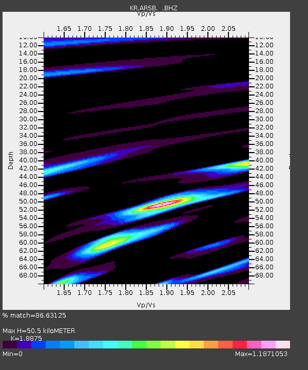
| Estimated Moho Depth: |
50.5 km |
| Estimated Crust Vp/Vs: |
1.89 |
| Assumed Crust Vp: |
6.306 km/s |
| Estimated Crust Vs: |
3.341 km/s |
| Estimated Crust Poisson's Ratio: |
0.30 |
|
| Radial Match: |
86.63125 % |
| Radial Bump: |
400 |
| Transverse Match: |
79.08544 % |
| Transverse Bump: |
400 |
| SOD ConfigId: |
512894 |
| Insert Time: |
2013-09-13 12:10:46.442 +0000 |
| GWidth: |
2.5 |
| Max Bumps: |
400 |
| Tol: |
0.001 |
|

Signal To Noise
| Channel | StoN | STA | LTA |
| KR:ARSB: :BHZ:20130419T18:02:17.550002Z | 14.134729 | 1.3111488E-6 | 9.27608E-8 |
| KR:ARSB: :BHN:20130419T18:02:17.550002Z | 5.3710775 | 4.5254936E-7 | 8.425671E-8 |
| KR:ARSB: :BHE:20130419T18:02:17.550002Z | 2.5535736 | 4.3583788E-7 | 1.7067762E-7 |
| Arrivals |
| Ps | 7.4 SECOND |
| PpPs | 22 SECOND |
| PsPs/PpSs | 30 SECOND |


