You are here: Home > Network List > TJ - Tajikistan National Seismic Network Stations List
> Station GARM Garm, Tajikistan > Earthquake Result Viewer
GARM Garm, Tajikistan - Earthquake Result Viewer
| Earthquake location: |
South Of Timor, Indonesia |
| Earthquake latitude/longitude: |
-12.0/121.6 |
| Earthquake time(UTC): |
2013/04/19 (109) 17:51:41 GMT |
| Earthquake Depth: |
15 km |
| Earthquake Magnitude: |
5.8 MW, 5.7 MW, 6.0 MB |
| Earthquake Catalog/Contributor: |
NEIC PDE/NEIC PDE-W |
|
| Network: |
TJ Tajikistan National Seismic Network |
| Station: |
GARM Garm, Tajikistan |
| Lat/Lon: |
39.00 N/70.32 E |
| Elevation: |
1305 m |
|
| Distance: |
69.7 deg |
| Az: |
319.561 deg |
| Baz: |
125.457 deg |
| Ray Param: |
0.05547891 |
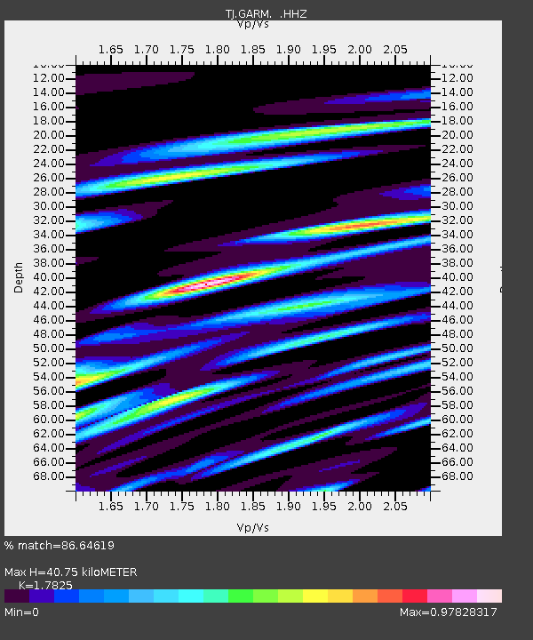
| Estimated Moho Depth: |
40.75 km |
| Estimated Crust Vp/Vs: |
1.78 |
| Assumed Crust Vp: |
6.306 km/s |
| Estimated Crust Vs: |
3.538 km/s |
| Estimated Crust Poisson's Ratio: |
0.27 |
|
| Radial Match: |
86.64619 % |
| Radial Bump: |
400 |
| Transverse Match: |
83.71758 % |
| Transverse Bump: |
400 |
| SOD ConfigId: |
512894 |
| Insert Time: |
2013-09-13 12:12:25.967 +0000 |
| GWidth: |
2.5 |
| Max Bumps: |
400 |
| Tol: |
0.001 |
|
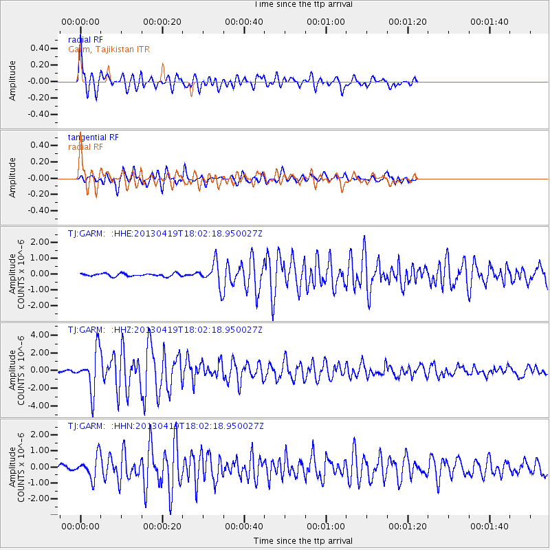
Signal To Noise
| Channel | StoN | STA | LTA |
| TJ:GARM: :HHZ:20130419T18:02:18.950027Z | 21.42796 | 2.3180778E-6 | 1.0818005E-7 |
| TJ:GARM: :HHN:20130419T18:02:18.950027Z | 7.9152374 | 7.1825036E-7 | 9.0742745E-8 |
| TJ:GARM: :HHE:20130419T18:02:18.950027Z | 8.780054 | 7.77564E-7 | 8.856028E-8 |
| Arrivals |
| Ps | 5.2 SECOND |
| PpPs | 17 SECOND |
| PsPs/PpSs | 23 SECOND |


