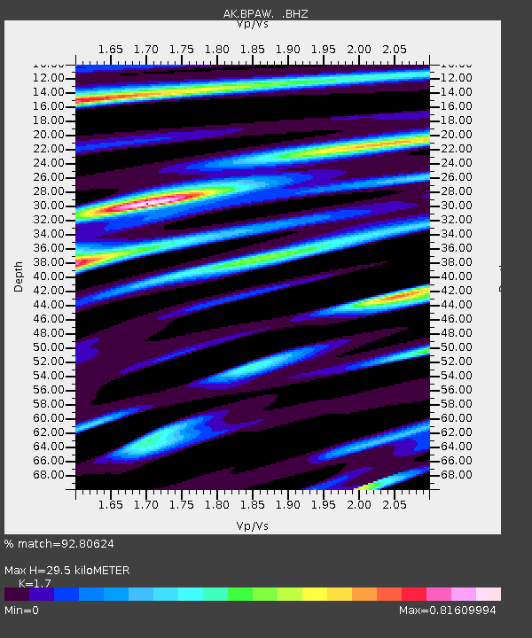
BPAW Bear Paw Mountain Broadband - Earthquake Result Viewer

Earthquake location: East Of Kuril Islands
Earthquake latitude/longitude: 50.0/157.7
Earthquake time(UTC): 2013/04/19 (109) 19:58:40 GMT
Earthquake Depth: 15 km
Earthquake Magnitude: 6.1 MW, 5.9 MB, 6.0 MW, 6.1 MS
Earthquake Catalog/Contributor: NEIC PDE/NEIC PDE-W
Network: AK Alaska Regional Network
Station: BPAW Bear Paw Mountain Broadband
Lat/Lon: 64.10 N/150.98 W
Elevation: 619 m
Distance: 30.3 deg
Az: 42.773 deg
Baz: 266.944 deg
Ray Param: 0.07935124
Estimated Moho Depth: 29.5 km
Estimated Crust Vp/Vs: 1.70
Assumed Crust Vp: 6.566 km/s
Estimated Crust Vs: 3.862 km/s
Estimated Crust Poisson's Ratio: 0.24
Radial Match: 92.80624 %
Radial Bump: 343
Transverse Match: 68.767 %
Transverse Bump: 400
SOD ConfigId: 512894
Insert Time: 2013-09-13 12:13:51.363 +0000
GWidth: 2.5
Max Bumps: 400
Tol: 0.001

Signal To Noise

ChannelStoNSTALTA
AK:BPAW: :BHZ:20130419T20:04:20.528015Z5.16518265.467942E-71.05861545E-7
AK:BPAW: :BHN:20130419T20:04:20.528015Z1.47923531.4500962E-79.803013E-8
AK:BPAW: :BHE:20130419T20:04:20.528015Z4.3529263.4359985E-77.893538E-8
Arrivals
Ps3.4 SECOND
PpPs11 SECOND
PsPs/PpSs15 SECOND