You are here: Home > Network List > AK - Alaska Regional Network Stations List
> Station JIS Juneau Island, AK, USA > Earthquake Result Viewer
JIS Juneau Island, AK, USA - Earthquake Result Viewer
| Earthquake location: |
East Of Kuril Islands |
| Earthquake latitude/longitude: |
50.0/157.7 |
| Earthquake time(UTC): |
2013/04/19 (109) 19:58:40 GMT |
| Earthquake Depth: |
15 km |
| Earthquake Magnitude: |
6.1 MW, 5.9 MB, 6.0 MW, 6.1 MS |
| Earthquake Catalog/Contributor: |
NEIC PDE/NEIC PDE-W |
|
| Network: |
AK Alaska Regional Network |
| Station: |
JIS Juneau Island, AK, USA |
| Lat/Lon: |
58.28 N/134.38 W |
| Elevation: |
10 m |
|
| Distance: |
39.1 deg |
| Az: |
50.979 deg |
| Baz: |
288.279 deg |
| Ray Param: |
0.075177535 |
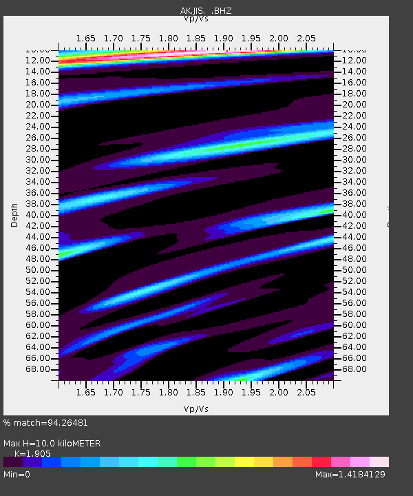
| Estimated Moho Depth: |
10.0 km |
| Estimated Crust Vp/Vs: |
1.90 |
| Assumed Crust Vp: |
6.566 km/s |
| Estimated Crust Vs: |
3.447 km/s |
| Estimated Crust Poisson's Ratio: |
0.31 |
|
| Radial Match: |
94.26481 % |
| Radial Bump: |
294 |
| Transverse Match: |
78.714554 % |
| Transverse Bump: |
400 |
| SOD ConfigId: |
512894 |
| Insert Time: |
2013-09-13 12:14:34.634 +0000 |
| GWidth: |
2.5 |
| Max Bumps: |
400 |
| Tol: |
0.001 |
|

Signal To Noise
| Channel | StoN | STA | LTA |
| AK:JIS: :BHZ:20130419T20:05:35.787994Z | 2.8718662 | 3.5806954E-7 | 1.2468183E-7 |
| AK:JIS: :BHN:20130419T20:05:35.787994Z | 1.1486387 | 1.3000795E-7 | 1.1318436E-7 |
| AK:JIS: :BHE:20130419T20:05:35.787994Z | 1.10926 | 1.3786777E-7 | 1.2428806E-7 |
| Arrivals |
| Ps | 1.5 SECOND |
| PpPs | 4.1 SECOND |
| PsPs/PpSs | 5.6 SECOND |


