You are here: Home > Network List > AK - Alaska Regional Network Stations List
> Station KLU Klutina Pass, AK, USA > Earthquake Result Viewer
KLU Klutina Pass, AK, USA - Earthquake Result Viewer
| Earthquake location: |
East Of Kuril Islands |
| Earthquake latitude/longitude: |
50.0/157.7 |
| Earthquake time(UTC): |
2013/04/19 (109) 19:58:40 GMT |
| Earthquake Depth: |
15 km |
| Earthquake Magnitude: |
6.1 MW, 5.9 MB, 6.0 MW, 6.1 MS |
| Earthquake Catalog/Contributor: |
NEIC PDE/NEIC PDE-W |
|
| Network: |
AK Alaska Regional Network |
| Station: |
KLU Klutina Pass, AK, USA |
| Lat/Lon: |
61.49 N/145.92 W |
| Elevation: |
1047 m |
|
| Distance: |
32.7 deg |
| Az: |
47.674 deg |
| Baz: |
275.62 deg |
| Ray Param: |
0.07851875 |
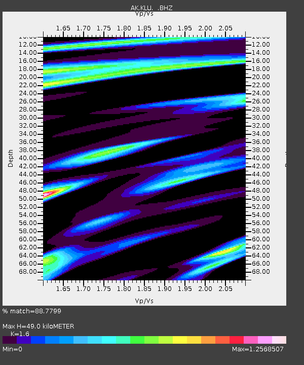
| Estimated Moho Depth: |
49.0 km |
| Estimated Crust Vp/Vs: |
1.60 |
| Assumed Crust Vp: |
6.566 km/s |
| Estimated Crust Vs: |
4.104 km/s |
| Estimated Crust Poisson's Ratio: |
0.18 |
|
| Radial Match: |
88.7799 % |
| Radial Bump: |
382 |
| Transverse Match: |
77.66063 % |
| Transverse Bump: |
400 |
| SOD ConfigId: |
512894 |
| Insert Time: |
2013-09-13 12:14:42.552 +0000 |
| GWidth: |
2.5 |
| Max Bumps: |
400 |
| Tol: |
0.001 |
|

Signal To Noise
| Channel | StoN | STA | LTA |
| AK:KLU: :BHZ:20130419T20:04:41.488007Z | 6.097414 | 4.4254915E-7 | 7.2579816E-8 |
| AK:KLU: :BHN:20130419T20:04:41.488007Z | 1.9363699 | 1.2279497E-7 | 6.3415044E-8 |
| AK:KLU: :BHE:20130419T20:04:41.488007Z | 4.666416 | 2.9447565E-7 | 6.310532E-8 |
| Arrivals |
| Ps | 4.9 SECOND |
| PpPs | 18 SECOND |
| PsPs/PpSs | 23 SECOND |


