You are here: Home > Network List > AK - Alaska Regional Network Stations List
> Station MLY Manley Hot Springs, Alaska, USA > Earthquake Result Viewer
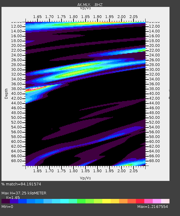
MLY Manley Hot Springs, Alaska, USA - Earthquake Result Viewer
| Earthquake location: |
East Of Kuril Islands |
| Earthquake latitude/longitude: |
50.0/157.7 |
| Earthquake time(UTC): |
2013/04/19 (109) 19:58:40 GMT |
| Earthquake Depth: |
15 km |
| Earthquake Magnitude: |
6.1 MW, 5.9 MB, 6.0 MW, 6.1 MS |
| Earthquake Catalog/Contributor: |
NEIC PDE/NEIC PDE-W |
|
| Network: |
AK Alaska Regional Network |
| Station: |
MLY Manley Hot Springs, Alaska, USA |
| Lat/Lon: |
65.03 N/150.74 W |
| Elevation: |
804 m |
|
| Distance: |
30.5 deg |
| Az: |
40.945 deg |
| Baz: |
265.589 deg |
| Ray Param: |
0.079307444 |
| Estimated Moho Depth: |
37.25 km |
| Estimated Crust Vp/Vs: |
1.65 |
| Assumed Crust Vp: |
6.566 km/s |
| Estimated Crust Vs: |
3.98 km/s |
| Estimated Crust Poisson's Ratio: |
0.21 |
|
| Radial Match: |
94.191574 % |
| Radial Bump: |
258 |
| Transverse Match: |
92.0488 % |
| Transverse Bump: |
315 |
| SOD ConfigId: |
512894 |
| Insert Time: |
2013-09-13 12:14:58.047 +0000 |
| GWidth: |
2.5 |
| Max Bumps: |
400 |
| Tol: |
0.001 |
|

Signal To Noise
| Channel | StoN | STA | LTA |
| AK:MLY: :BHZ:20130419T20:04:21.988007Z | 15.8178005 | 8.281927E-7 | 5.235827E-8 |
| AK:MLY: :BHN:20130419T20:04:21.988007Z | 5.618128 | 2.614348E-7 | 4.6534147E-8 |
| AK:MLY: :BHE:20130419T20:04:21.988007Z | 7.509415 | 4.0992384E-7 | 5.4587986E-8 |
| Arrivals |
| Ps | 4.0 SECOND |
| PpPs | 14 SECOND |
| PsPs/PpSs | 18 SECOND |


