You are here: Home > Network List > AU - Australian Seismological Centre Stations List
> Station RABL Rabaul, Papau New Guinea > Earthquake Result Viewer
RABL Rabaul, Papau New Guinea - Earthquake Result Viewer
| Earthquake location: |
East Of Kuril Islands |
| Earthquake latitude/longitude: |
50.0/157.7 |
| Earthquake time(UTC): |
2013/04/19 (109) 19:58:40 GMT |
| Earthquake Depth: |
15 km |
| Earthquake Magnitude: |
6.1 MW, 5.9 MB, 6.0 MW, 6.1 MS |
| Earthquake Catalog/Contributor: |
NEIC PDE/NEIC PDE-W |
|
| Network: |
AU Australian Seismological Centre |
| Station: |
RABL Rabaul, Papau New Guinea |
| Lat/Lon: |
4.19 S/152.16 E |
| Elevation: |
277 m |
|
| Distance: |
54.1 deg |
| Az: |
186.759 deg |
| Baz: |
4.37 deg |
| Ray Param: |
0.06561772 |
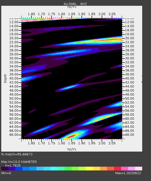
| Estimated Moho Depth: |
10.0 km |
| Estimated Crust Vp/Vs: |
1.79 |
| Assumed Crust Vp: |
6.183 km/s |
| Estimated Crust Vs: |
3.449 km/s |
| Estimated Crust Poisson's Ratio: |
0.27 |
|
| Radial Match: |
95.66673 % |
| Radial Bump: |
360 |
| Transverse Match: |
90.81481 % |
| Transverse Bump: |
400 |
| SOD ConfigId: |
512894 |
| Insert Time: |
2013-09-13 12:17:39.800 +0000 |
| GWidth: |
2.5 |
| Max Bumps: |
400 |
| Tol: |
0.001 |
|

Signal To Noise
| Channel | StoN | STA | LTA |
| AU:RABL: :BHZ:20130419T20:07:33.643982Z | 7.1424375 | 1.0105347E-6 | 1.4148316E-7 |
| AU:RABL: :BHN:20130419T20:07:33.643982Z | 4.065961 | 6.816259E-7 | 1.6764203E-7 |
| AU:RABL: :BHE:20130419T20:07:33.643982Z | 1.2664288 | 2.3204164E-7 | 1.8322517E-7 |
| Arrivals |
| Ps | 1.3 SECOND |
| PpPs | 4.3 SECOND |
| PsPs/PpSs | 5.6 SECOND |


