You are here: Home > Network List > AZ - ANZA Regional Network Stations List
> Station SMER AZ.SMER > Earthquake Result Viewer
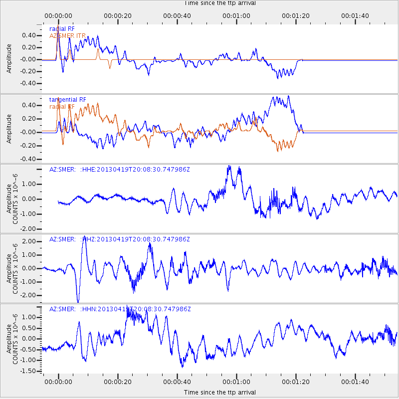
SMER AZ.SMER - Earthquake Result Viewer
*The percent match for this event was below the threshold and hence no stack was calculated.
| Earthquake location: |
East Of Kuril Islands |
| Earthquake latitude/longitude: |
50.0/157.7 |
| Earthquake time(UTC): |
2013/04/19 (109) 19:58:40 GMT |
| Earthquake Depth: |
15 km |
| Earthquake Magnitude: |
6.1 MW, 5.9 MB, 6.0 MW, 6.1 MS |
| Earthquake Catalog/Contributor: |
NEIC PDE/NEIC PDE-W |
|
| Network: |
AZ ANZA Regional Network |
| Station: |
SMER AZ.SMER |
| Lat/Lon: |
33.46 N/117.17 W |
| Elevation: |
355 m |
|
| Distance: |
62.3 deg |
| Az: |
70.151 deg |
| Baz: |
313.399 deg |
| Ray Param: |
$rayparam |
*The percent match for this event was below the threshold and hence was not used in the summary stack. |
|
| Radial Match: |
39.4825 % |
| Radial Bump: |
400 |
| Transverse Match: |
19.048096 % |
| Transverse Bump: |
400 |
| SOD ConfigId: |
512894 |
| Insert Time: |
2013-09-13 12:18:18.889 +0000 |
| GWidth: |
2.5 |
| Max Bumps: |
400 |
| Tol: |
0.001 |
|
Signal To Noise
| Channel | StoN | STA | LTA |
| AZ:SMER: :HHZ:20130419T20:08:30.747986Z | 2.054903 | 2.0726178E-7 | 1.00862074E-7 |
| AZ:SMER: :HHN:20130419T20:08:30.747986Z | 1.5417178 | 4.789832E-7 | 3.1068151E-7 |
| AZ:SMER: :HHE:20130419T20:08:30.747986Z | 0.9352094 | 1.7280529E-7 | 1.8477711E-7 |
| Arrivals |
| Ps | |
| PpPs | |
| PsPs/PpSs | |


