You are here: Home > Network List > CB - China National Seismic Network Stations List
> Station LYN Luoyang,Henan Province > Earthquake Result Viewer
LYN Luoyang,Henan Province - Earthquake Result Viewer
| Earthquake location: |
East Of Kuril Islands |
| Earthquake latitude/longitude: |
50.0/157.7 |
| Earthquake time(UTC): |
2013/04/19 (109) 19:58:40 GMT |
| Earthquake Depth: |
15 km |
| Earthquake Magnitude: |
6.1 MW, 5.9 MB, 6.0 MW, 6.1 MS |
| Earthquake Catalog/Contributor: |
NEIC PDE/NEIC PDE-W |
|
| Network: |
CB China National Seismic Network |
| Station: |
LYN Luoyang,Henan Province |
| Lat/Lon: |
34.55 N/112.47 E |
| Elevation: |
170 m |
|
| Distance: |
36.2 deg |
| Az: |
262.255 deg |
| Baz: |
50.828 deg |
| Ray Param: |
0.076787 |
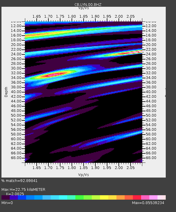
| Estimated Moho Depth: |
22.75 km |
| Estimated Crust Vp/Vs: |
2.08 |
| Assumed Crust Vp: |
6.155 km/s |
| Estimated Crust Vs: |
2.956 km/s |
| Estimated Crust Poisson's Ratio: |
0.35 |
|
| Radial Match: |
92.89841 % |
| Radial Bump: |
195 |
| Transverse Match: |
77.592735 % |
| Transverse Bump: |
400 |
| SOD ConfigId: |
512894 |
| Insert Time: |
2013-09-13 12:19:15.846 +0000 |
| GWidth: |
2.5 |
| Max Bumps: |
400 |
| Tol: |
0.001 |
|

Signal To Noise
| Channel | StoN | STA | LTA |
| CB:LYN:00:BHZ:20130419T20:05:11.619995Z | 39.10651 | 3.3207923E-6 | 8.491661E-8 |
| CB:LYN:00:BHN:20130419T20:05:11.619995Z | 14.347975 | 1.0724561E-6 | 7.474617E-8 |
| CB:LYN:00:BHE:20130419T20:05:11.619995Z | 20.82176 | 1.626739E-6 | 7.812688E-8 |
| Arrivals |
| Ps | 4.2 SECOND |
| PpPs | 11 SECOND |
| PsPs/PpSs | 15 SECOND |


