You are here: Home > Network List > CN - Canadian National Seismograph Network Stations List
> Station ATKO ATIKOKAN IRON MINE, ON > Earthquake Result Viewer
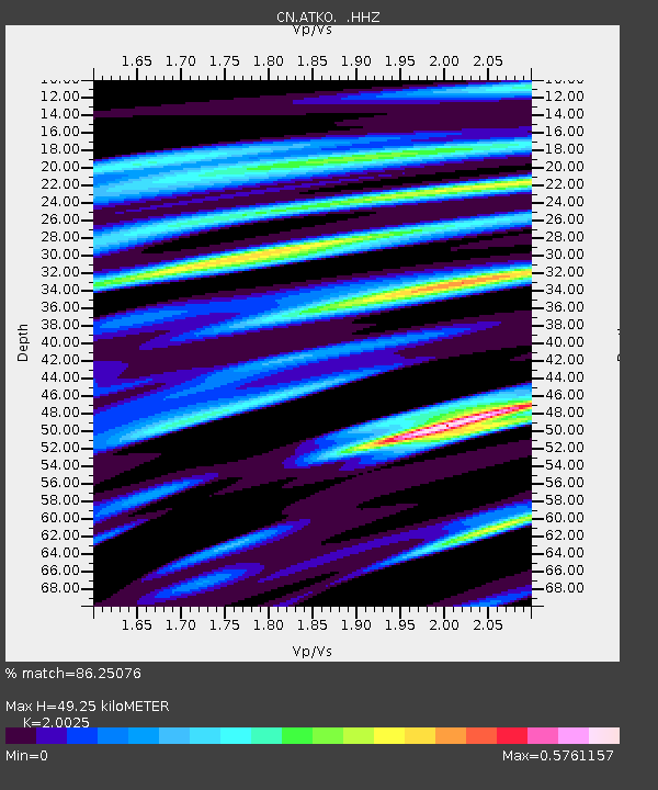
ATKO ATIKOKAN IRON MINE, ON - Earthquake Result Viewer
| Earthquake location: |
East Of Kuril Islands |
| Earthquake latitude/longitude: |
50.0/157.7 |
| Earthquake time(UTC): |
2013/04/19 (109) 19:58:40 GMT |
| Earthquake Depth: |
15 km |
| Earthquake Magnitude: |
6.1 MW, 5.9 MB, 6.0 MW, 6.1 MS |
| Earthquake Catalog/Contributor: |
NEIC PDE/NEIC PDE-W |
|
| Network: |
CN Canadian National Seismograph Network |
| Station: |
ATKO ATIKOKAN IRON MINE, ON |
| Lat/Lon: |
48.82 N/91.60 W |
| Elevation: |
383 m |
|
| Distance: |
65.1 deg |
| Az: |
42.972 deg |
| Baz: |
318.236 deg |
| Ray Param: |
0.05851553 |
| Estimated Moho Depth: |
49.25 km |
| Estimated Crust Vp/Vs: |
2.00 |
| Assumed Crust Vp: |
6.467 km/s |
| Estimated Crust Vs: |
3.229 km/s |
| Estimated Crust Poisson's Ratio: |
0.33 |
|
| Radial Match: |
86.25076 % |
| Radial Bump: |
400 |
| Transverse Match: |
52.802067 % |
| Transverse Bump: |
400 |
| SOD ConfigId: |
512894 |
| Insert Time: |
2013-09-13 12:21:55.656 +0000 |
| GWidth: |
2.5 |
| Max Bumps: |
400 |
| Tol: |
0.001 |
|

Signal To Noise
| Channel | StoN | STA | LTA |
| CN:ATKO: :HHZ:20130419T20:08:48.669983Z | 3.9434707 | 2.857297E-7 | 7.24564E-8 |
| CN:ATKO: :HHN:20130419T20:08:48.669983Z | 3.1962364 | 1.2277746E-7 | 3.8413138E-8 |
| CN:ATKO: :HHE:20130419T20:08:48.669983Z | 1.7873701 | 1.046374E-7 | 5.854266E-8 |
| Arrivals |
| Ps | 7.9 SECOND |
| PpPs | 22 SECOND |
| PsPs/PpSs | 30 SECOND |


