You are here: Home > Network List > G - GEOSCOPE Stations List
> Station CLF Chambon la Foret observatory, France > Earthquake Result Viewer
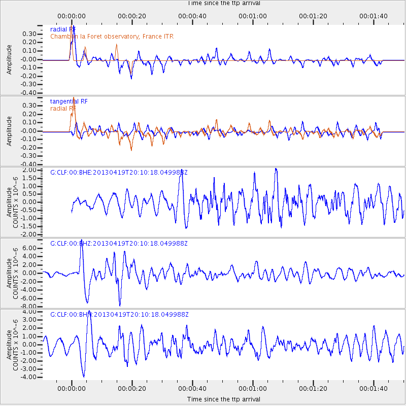
CLF Chambon la Foret observatory, France - Earthquake Result Viewer
*The percent match for this event was below the threshold and hence no stack was calculated.
| Earthquake location: |
East Of Kuril Islands |
| Earthquake latitude/longitude: |
50.0/157.7 |
| Earthquake time(UTC): |
2013/04/19 (109) 19:58:40 GMT |
| Earthquake Depth: |
15 km |
| Earthquake Magnitude: |
6.1 MW, 5.9 MB, 6.0 MW, 6.1 MS |
| Earthquake Catalog/Contributor: |
NEIC PDE/NEIC PDE-W |
|
| Network: |
G GEOSCOPE |
| Station: |
CLF Chambon la Foret observatory, France |
| Lat/Lon: |
48.03 N/2.26 E |
| Elevation: |
145 m |
|
| Distance: |
80.1 deg |
| Az: |
343.516 deg |
| Baz: |
15.841 deg |
| Ray Param: |
$rayparam |
*The percent match for this event was below the threshold and hence was not used in the summary stack. |
|
| Radial Match: |
74.91254 % |
| Radial Bump: |
400 |
| Transverse Match: |
68.63585 % |
| Transverse Bump: |
400 |
| SOD ConfigId: |
512894 |
| Insert Time: |
2013-09-13 12:25:18.341 +0000 |
| GWidth: |
2.5 |
| Max Bumps: |
400 |
| Tol: |
0.001 |
|
Signal To Noise
| Channel | StoN | STA | LTA |
| G:CLF:00:BHZ:20130419T20:10:18.049988Z | 6.505957 | 3.3450926E-6 | 5.141584E-7 |
| G:CLF:00:BHN:20130419T20:10:18.049988Z | 2.8528824 | 1.6620144E-6 | 5.8257376E-7 |
| G:CLF:00:BHE:20130419T20:10:18.049988Z | 1.3048403 | 5.1171776E-7 | 3.9216886E-7 |
| Arrivals |
| Ps | |
| PpPs | |
| PsPs/PpSs | |


