You are here: Home > Network List > GO - National Seismic Network of Georgia Stations List
> Station BGD Bogdanovka, Georgia > Earthquake Result Viewer
BGD Bogdanovka, Georgia - Earthquake Result Viewer
| Earthquake location: |
East Of Kuril Islands |
| Earthquake latitude/longitude: |
50.0/157.7 |
| Earthquake time(UTC): |
2013/04/19 (109) 19:58:40 GMT |
| Earthquake Depth: |
15 km |
| Earthquake Magnitude: |
6.1 MW, 5.9 MB, 6.0 MW, 6.1 MS |
| Earthquake Catalog/Contributor: |
NEIC PDE/NEIC PDE-W |
|
| Network: |
GO National Seismic Network of Georgia |
| Station: |
BGD Bogdanovka, Georgia |
| Lat/Lon: |
41.26 N/43.60 E |
| Elevation: |
1978 m |
|
| Distance: |
72.3 deg |
| Az: |
313.746 deg |
| Baz: |
38.232 deg |
| Ray Param: |
0.053709812 |
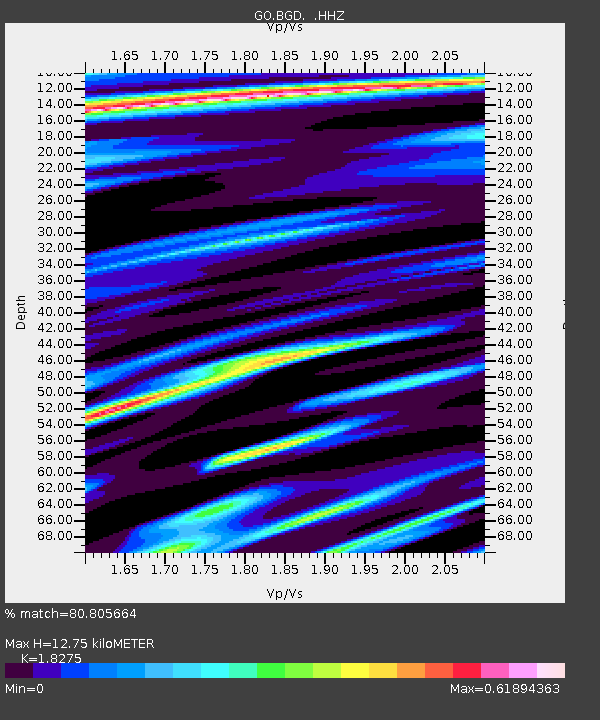
| Estimated Moho Depth: |
12.75 km |
| Estimated Crust Vp/Vs: |
1.83 |
| Assumed Crust Vp: |
6.419 km/s |
| Estimated Crust Vs: |
3.513 km/s |
| Estimated Crust Poisson's Ratio: |
0.29 |
|
| Radial Match: |
80.805664 % |
| Radial Bump: |
400 |
| Transverse Match: |
72.59588 % |
| Transverse Bump: |
400 |
| SOD ConfigId: |
512894 |
| Insert Time: |
2013-09-13 12:26:39.118 +0000 |
| GWidth: |
2.5 |
| Max Bumps: |
400 |
| Tol: |
0.001 |
|

Signal To Noise
| Channel | StoN | STA | LTA |
| GO:BGD: :HHZ:20130419T20:09:34.049988Z | 18.1699 | 1.436441E-6 | 7.905607E-8 |
| GO:BGD: :HHN:20130419T20:09:34.049988Z | 2.1003737 | 2.5158045E-7 | 1.1977889E-7 |
| GO:BGD: :HHE:20130419T20:09:34.049988Z | 3.0167508 | 2.76186E-7 | 9.155082E-8 |
| Arrivals |
| Ps | 1.7 SECOND |
| PpPs | 5.4 SECOND |
| PsPs/PpSs | 7.1 SECOND |


