You are here: Home > Network List > GO - National Seismic Network of Georgia Stations List
> Station TBLG Delisi, Georgia > Earthquake Result Viewer
TBLG Delisi, Georgia - Earthquake Result Viewer
| Earthquake location: |
East Of Kuril Islands |
| Earthquake latitude/longitude: |
50.0/157.7 |
| Earthquake time(UTC): |
2013/04/19 (109) 19:58:40 GMT |
| Earthquake Depth: |
15 km |
| Earthquake Magnitude: |
6.1 MW, 5.9 MB, 6.0 MW, 6.1 MS |
| Earthquake Catalog/Contributor: |
NEIC PDE/NEIC PDE-W |
|
| Network: |
GO National Seismic Network of Georgia |
| Station: |
TBLG Delisi, Georgia |
| Lat/Lon: |
41.73 N/44.74 E |
| Elevation: |
510 m |
|
| Distance: |
71.5 deg |
| Az: |
313.347 deg |
| Baz: |
38.86 deg |
| Ray Param: |
0.054309882 |
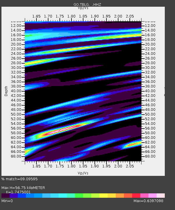
| Estimated Moho Depth: |
56.75 km |
| Estimated Crust Vp/Vs: |
1.75 |
| Assumed Crust Vp: |
6.291 km/s |
| Estimated Crust Vs: |
3.6 km/s |
| Estimated Crust Poisson's Ratio: |
0.26 |
|
| Radial Match: |
89.09595 % |
| Radial Bump: |
400 |
| Transverse Match: |
88.66164 % |
| Transverse Bump: |
400 |
| SOD ConfigId: |
512894 |
| Insert Time: |
2013-09-13 12:27:03.717 +0000 |
| GWidth: |
2.5 |
| Max Bumps: |
400 |
| Tol: |
0.001 |
|

Signal To Noise
| Channel | StoN | STA | LTA |
| GO:TBLG: :HHZ:20130419T20:09:28.669983Z | 48.161358 | 3.9728475E-6 | 8.249036E-8 |
| GO:TBLG: :HHN:20130419T20:09:28.669983Z | 11.761062 | 5.9965305E-7 | 5.0986305E-8 |
| GO:TBLG: :HHE:20130419T20:09:28.669983Z | 12.216274 | 8.611633E-7 | 7.0493115E-8 |
| Arrivals |
| Ps | 7.0 SECOND |
| PpPs | 24 SECOND |
| PsPs/PpSs | 31 SECOND |


