You are here: Home > Network List > IC - New China Digital Seismograph Network Stations List
> Station QIZ Qiongzhong, Hainan Province, China > Earthquake Result Viewer
QIZ Qiongzhong, Hainan Province, China - Earthquake Result Viewer
| Earthquake location: |
East Of Kuril Islands |
| Earthquake latitude/longitude: |
50.0/157.7 |
| Earthquake time(UTC): |
2013/04/19 (109) 19:58:40 GMT |
| Earthquake Depth: |
15 km |
| Earthquake Magnitude: |
6.1 MW, 5.9 MB, 6.0 MW, 6.1 MS |
| Earthquake Catalog/Contributor: |
NEIC PDE/NEIC PDE-W |
|
| Network: |
IC New China Digital Seismograph Network |
| Station: |
QIZ Qiongzhong, Hainan Province, China |
| Lat/Lon: |
19.03 N/109.84 E |
| Elevation: |
240 m |
|
| Distance: |
48.9 deg |
| Az: |
248.519 deg |
| Baz: |
39.436 deg |
| Ray Param: |
0.06906001 |
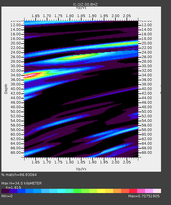
| Estimated Moho Depth: |
34.0 km |
| Estimated Crust Vp/Vs: |
1.62 |
| Assumed Crust Vp: |
6.182 km/s |
| Estimated Crust Vs: |
3.828 km/s |
| Estimated Crust Poisson's Ratio: |
0.19 |
|
| Radial Match: |
96.93064 % |
| Radial Bump: |
315 |
| Transverse Match: |
82.49118 % |
| Transverse Bump: |
400 |
| SOD ConfigId: |
512894 |
| Insert Time: |
2013-09-13 12:28:29.950 +0000 |
| GWidth: |
2.5 |
| Max Bumps: |
400 |
| Tol: |
0.001 |
|
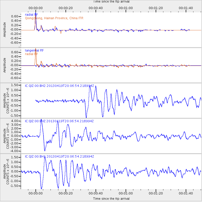
Signal To Noise
| Channel | StoN | STA | LTA |
| IC:QIZ:00:BHZ:20130419T20:06:54.218994Z | 16.819834 | 1.8441007E-6 | 1.0963846E-7 |
| IC:QIZ:00:BH1:20130419T20:06:54.218994Z | 9.738739 | 7.841842E-7 | 8.052215E-8 |
| IC:QIZ:00:BH2:20130419T20:06:54.218994Z | 12.621196 | 6.587041E-7 | 5.219031E-8 |
| Arrivals |
| Ps | 3.6 SECOND |
| PpPs | 14 SECOND |
| PsPs/PpSs | 17 SECOND |


