You are here: Home > Network List > IU - Global Seismograph Network (GSN - IRIS/USGS) Stations List
> Station CTAO Charters Towers, Australia > Earthquake Result Viewer
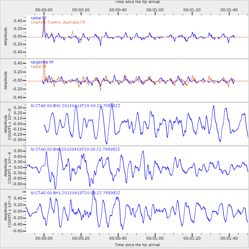
CTAO Charters Towers, Australia - Earthquake Result Viewer
*The percent match for this event was below the threshold and hence no stack was calculated.
| Earthquake location: |
East Of Kuril Islands |
| Earthquake latitude/longitude: |
50.0/157.7 |
| Earthquake time(UTC): |
2013/04/19 (109) 19:58:40 GMT |
| Earthquake Depth: |
15 km |
| Earthquake Magnitude: |
6.1 MW, 5.9 MB, 6.0 MW, 6.1 MS |
| Earthquake Catalog/Contributor: |
NEIC PDE/NEIC PDE-W |
|
| Network: |
IU Global Seismograph Network (GSN - IRIS/USGS) |
| Station: |
CTAO Charters Towers, Australia |
| Lat/Lon: |
20.09 S/146.25 E |
| Elevation: |
357 m |
|
| Distance: |
70.5 deg |
| Az: |
191.366 deg |
| Baz: |
7.782 deg |
| Ray Param: |
$rayparam |
*The percent match for this event was below the threshold and hence was not used in the summary stack. |
|
| Radial Match: |
70.937065 % |
| Radial Bump: |
336 |
| Transverse Match: |
50.499096 % |
| Transverse Bump: |
360 |
| SOD ConfigId: |
512894 |
| Insert Time: |
2013-09-13 12:30:08.338 +0000 |
| GWidth: |
2.5 |
| Max Bumps: |
400 |
| Tol: |
0.001 |
|
Signal To Noise
| Channel | StoN | STA | LTA |
| IU:CTAO:00:BHZ:20130419T20:09:22.768982Z | 3.511466 | 4.428259E-7 | 1.2610856E-7 |
| IU:CTAO:00:BH1:20130419T20:09:22.768982Z | 2.1395712 | 2.353682E-7 | 1.10007186E-7 |
| IU:CTAO:00:BH2:20130419T20:09:22.768982Z | 1.6615622 | 2.4026122E-7 | 1.445996E-7 |
| Arrivals |
| Ps | |
| PpPs | |
| PsPs/PpSs | |


