You are here: Home > Network List > IW - Intermountain West Stations List
> Station SNOW Snow King Mountain, Wyoming, USA > Earthquake Result Viewer
SNOW Snow King Mountain, Wyoming, USA - Earthquake Result Viewer
| Earthquake location: |
East Of Kuril Islands |
| Earthquake latitude/longitude: |
50.0/157.7 |
| Earthquake time(UTC): |
2013/04/19 (109) 19:58:40 GMT |
| Earthquake Depth: |
15 km |
| Earthquake Magnitude: |
6.1 MW, 5.9 MB, 6.0 MW, 6.1 MS |
| Earthquake Catalog/Contributor: |
NEIC PDE/NEIC PDE-W |
|
| Network: |
IW Intermountain West |
| Station: |
SNOW Snow King Mountain, Wyoming, USA |
| Lat/Lon: |
43.46 N/110.76 W |
| Elevation: |
2390 m |
|
| Distance: |
59.3 deg |
| Az: |
57.814 deg |
| Baz: |
311.356 deg |
| Ray Param: |
0.062256478 |
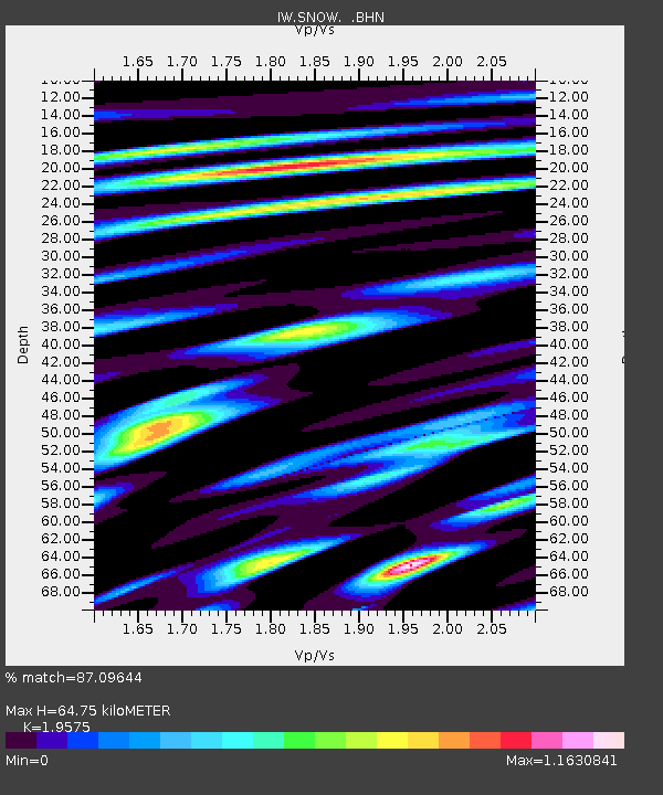
| Estimated Moho Depth: |
64.75 km |
| Estimated Crust Vp/Vs: |
1.96 |
| Assumed Crust Vp: |
6.207 km/s |
| Estimated Crust Vs: |
3.171 km/s |
| Estimated Crust Poisson's Ratio: |
0.32 |
|
| Radial Match: |
87.09644 % |
| Radial Bump: |
400 |
| Transverse Match: |
86.59333 % |
| Transverse Bump: |
400 |
| SOD ConfigId: |
512894 |
| Insert Time: |
2013-09-13 12:32:09.814 +0000 |
| GWidth: |
2.5 |
| Max Bumps: |
400 |
| Tol: |
0.001 |
|

Signal To Noise
| Channel | StoN | STA | LTA |
| IW:SNOW: :BHZ:20130419T20:08:10.314026Z | 2.9200692 | 2.9034354E-7 | 9.943036E-8 |
| IW:SNOW: :BHN:20130419T20:08:10.314026Z | 1.9325078 | 1.7552141E-7 | 9.0825715E-8 |
| IW:SNOW: :BHE:20130419T20:08:10.314026Z | 0.88441086 | 1.5331857E-7 | 1.7335672E-7 |
| Arrivals |
| Ps | 10 SECOND |
| PpPs | 30 SECOND |
| PsPs/PpSs | 40 SECOND |


