You are here: Home > Network List > KR - Kyrgyz Digital Network Stations List
> Station FRU1 Bishkek, Kyrgyzstan > Earthquake Result Viewer
FRU1 Bishkek, Kyrgyzstan - Earthquake Result Viewer
| Earthquake location: |
East Of Kuril Islands |
| Earthquake latitude/longitude: |
50.0/157.7 |
| Earthquake time(UTC): |
2013/04/19 (109) 19:58:40 GMT |
| Earthquake Depth: |
15 km |
| Earthquake Magnitude: |
6.1 MW, 5.9 MB, 6.0 MW, 6.1 MS |
| Earthquake Catalog/Contributor: |
NEIC PDE/NEIC PDE-W |
|
| Network: |
KR Kyrgyz Digital Network |
| Station: |
FRU1 Bishkek, Kyrgyzstan |
| Lat/Lon: |
42.81 N/74.63 E |
| Elevation: |
929 m |
|
| Distance: |
54.9 deg |
| Az: |
296.805 deg |
| Baz: |
51.563 deg |
| Ray Param: |
0.0651256 |
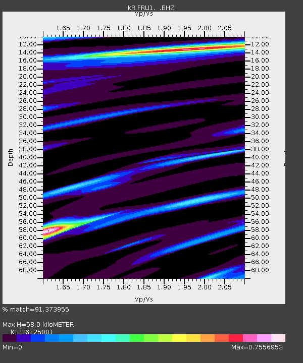
| Estimated Moho Depth: |
58.0 km |
| Estimated Crust Vp/Vs: |
1.61 |
| Assumed Crust Vp: |
6.306 km/s |
| Estimated Crust Vs: |
3.911 km/s |
| Estimated Crust Poisson's Ratio: |
0.19 |
|
| Radial Match: |
91.373955 % |
| Radial Bump: |
400 |
| Transverse Match: |
83.83911 % |
| Transverse Bump: |
400 |
| SOD ConfigId: |
512894 |
| Insert Time: |
2013-09-13 12:32:56.832 +0000 |
| GWidth: |
2.5 |
| Max Bumps: |
400 |
| Tol: |
0.001 |
|

Signal To Noise
| Channel | StoN | STA | LTA |
| KR:FRU1: :BHZ:20130419T20:07:39.250Z | 31.268225 | 2.2782788E-6 | 7.286243E-8 |
| KR:FRU1: :BHN:20130419T20:07:39.250Z | 1.9762344 | 2.890152E-7 | 1.462454E-7 |
| KR:FRU1: :BHE:20130419T20:07:39.250Z | 9.046452 | 8.275054E-7 | 9.147292E-8 |
| Arrivals |
| Ps | 6.0 SECOND |
| PpPs | 23 SECOND |
| PsPs/PpSs | 29 SECOND |


