You are here: Home > Network List > LD - Lamont-Doherty Cooperative Seismographic Network Stations List
> Station BRNJ Basking Ridge, New Jersey > Earthquake Result Viewer
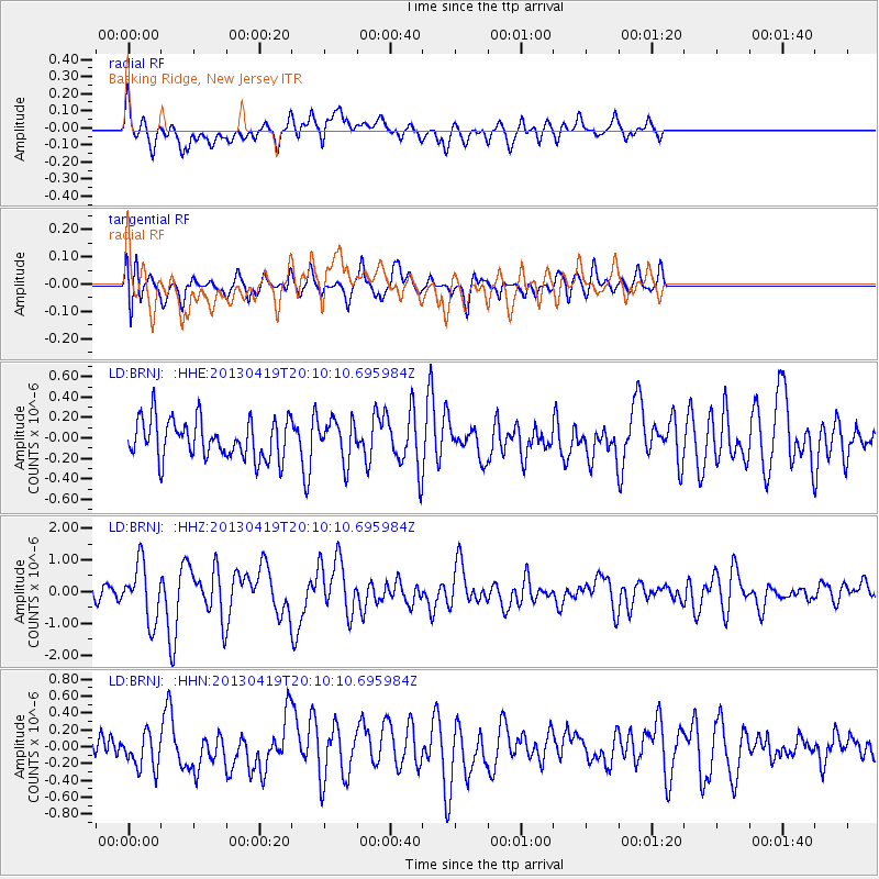
BRNJ Basking Ridge, New Jersey - Earthquake Result Viewer
*The percent match for this event was below the threshold and hence no stack was calculated.
| Earthquake location: |
East Of Kuril Islands |
| Earthquake latitude/longitude: |
50.0/157.7 |
| Earthquake time(UTC): |
2013/04/19 (109) 19:58:40 GMT |
| Earthquake Depth: |
15 km |
| Earthquake Magnitude: |
6.1 MW, 5.9 MB, 6.0 MW, 6.1 MS |
| Earthquake Catalog/Contributor: |
NEIC PDE/NEIC PDE-W |
|
| Network: |
LD Lamont-Doherty Cooperative Seismographic Network |
| Station: |
BRNJ Basking Ridge, New Jersey |
| Lat/Lon: |
40.68 N/74.57 W |
| Elevation: |
50 m |
|
| Distance: |
78.8 deg |
| Az: |
37.792 deg |
| Baz: |
328.643 deg |
| Ray Param: |
$rayparam |
*The percent match for this event was below the threshold and hence was not used in the summary stack. |
|
| Radial Match: |
61.622204 % |
| Radial Bump: |
400 |
| Transverse Match: |
60.13737 % |
| Transverse Bump: |
400 |
| SOD ConfigId: |
512894 |
| Insert Time: |
2013-09-13 12:33:38.594 +0000 |
| GWidth: |
2.5 |
| Max Bumps: |
400 |
| Tol: |
0.001 |
|
Signal To Noise
| Channel | StoN | STA | LTA |
| LD:BRNJ: :HHZ:20130419T20:10:10.695984Z | 3.7657864 | 8.8791904E-7 | 2.3578582E-7 |
| LD:BRNJ: :HHN:20130419T20:10:10.695984Z | 0.98227483 | 2.0718221E-7 | 2.1092082E-7 |
| LD:BRNJ: :HHE:20130419T20:10:10.695984Z | 1.0442013 | 1.9894895E-7 | 1.9052742E-7 |
| Arrivals |
| Ps | |
| PpPs | |
| PsPs/PpSs | |


