You are here: Home > Network List > LD - Lamont-Doherty Cooperative Seismographic Network Stations List
> Station LUPA Lehigh University, PA > Earthquake Result Viewer
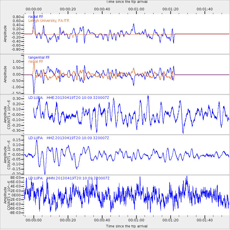
LUPA Lehigh University, PA - Earthquake Result Viewer
*The percent match for this event was below the threshold and hence no stack was calculated.
| Earthquake location: |
East Of Kuril Islands |
| Earthquake latitude/longitude: |
50.0/157.7 |
| Earthquake time(UTC): |
2013/04/19 (109) 19:58:40 GMT |
| Earthquake Depth: |
15 km |
| Earthquake Magnitude: |
6.1 MW, 5.9 MB, 6.0 MW, 6.1 MS |
| Earthquake Catalog/Contributor: |
NEIC PDE/NEIC PDE-W |
|
| Network: |
LD Lamont-Doherty Cooperative Seismographic Network |
| Station: |
LUPA Lehigh University, PA |
| Lat/Lon: |
40.60 N/75.37 W |
| Elevation: |
236 m |
|
| Distance: |
78.5 deg |
| Az: |
38.37 deg |
| Baz: |
328.234 deg |
| Ray Param: |
$rayparam |
*The percent match for this event was below the threshold and hence was not used in the summary stack. |
|
| Radial Match: |
67.78221 % |
| Radial Bump: |
400 |
| Transverse Match: |
68.248924 % |
| Transverse Bump: |
400 |
| SOD ConfigId: |
512894 |
| Insert Time: |
2013-09-13 12:34:30.919 +0000 |
| GWidth: |
2.5 |
| Max Bumps: |
400 |
| Tol: |
0.001 |
|
Signal To Noise
| Channel | StoN | STA | LTA |
| LD:LUPA: :HHZ:20130419T20:10:09.320007Z | 4.795437 | 7.483909E-8 | 1.5606314E-8 |
| LD:LUPA: :HHN:20130419T20:10:09.320007Z | 1.1760467 | 3.4842218E-9 | 2.962656E-9 |
| LD:LUPA: :HHE:20130419T20:10:09.320007Z | 1.0640652 | 1.0897184E-7 | 1.02410866E-7 |
| Arrivals |
| Ps | |
| PpPs | |
| PsPs/PpSs | |


