You are here: Home > Network List > MN - MEDNET Project Stations List
> Station PDG Podgorica, Crna Gora > Earthquake Result Viewer
PDG Podgorica, Crna Gora - Earthquake Result Viewer
| Earthquake location: |
East Of Kuril Islands |
| Earthquake latitude/longitude: |
50.0/157.7 |
| Earthquake time(UTC): |
2013/04/19 (109) 19:58:40 GMT |
| Earthquake Depth: |
15 km |
| Earthquake Magnitude: |
6.1 MW, 5.9 MB, 6.0 MW, 6.1 MS |
| Earthquake Catalog/Contributor: |
NEIC PDE/NEIC PDE-W |
|
| Network: |
MN MEDNET Project |
| Station: |
PDG Podgorica, Crna Gora |
| Lat/Lon: |
42.43 N/19.26 E |
| Elevation: |
40 m |
|
| Distance: |
81.0 deg |
| Az: |
330.152 deg |
| Baz: |
25.73 deg |
| Ray Param: |
0.04785793 |
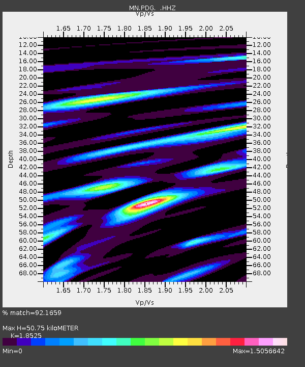
| Estimated Moho Depth: |
50.75 km |
| Estimated Crust Vp/Vs: |
1.85 |
| Assumed Crust Vp: |
6.291 km/s |
| Estimated Crust Vs: |
3.396 km/s |
| Estimated Crust Poisson's Ratio: |
0.29 |
|
| Radial Match: |
92.1659 % |
| Radial Bump: |
400 |
| Transverse Match: |
82.088936 % |
| Transverse Bump: |
400 |
| SOD ConfigId: |
512894 |
| Insert Time: |
2013-09-13 12:35:30.829 +0000 |
| GWidth: |
2.5 |
| Max Bumps: |
400 |
| Tol: |
0.001 |
|

Signal To Noise
| Channel | StoN | STA | LTA |
| MN:PDG: :HHZ:20130419T20:10:22.994019Z | 29.138727 | 2.2313375E-6 | 7.6576356E-8 |
| MN:PDG: :HHN:20130419T20:10:22.994019Z | 14.906838 | 8.1298913E-7 | 5.4538E-8 |
| MN:PDG: :HHE:20130419T20:10:22.994019Z | 7.191961 | 4.1625685E-7 | 5.7878076E-8 |
| Arrivals |
| Ps | 7.1 SECOND |
| PpPs | 22 SECOND |
| PsPs/PpSs | 29 SECOND |


