You are here: Home > Network List > NI - North-East Italy Broadband Network Stations List
> Station CGRP Cima Grappa > Earthquake Result Viewer
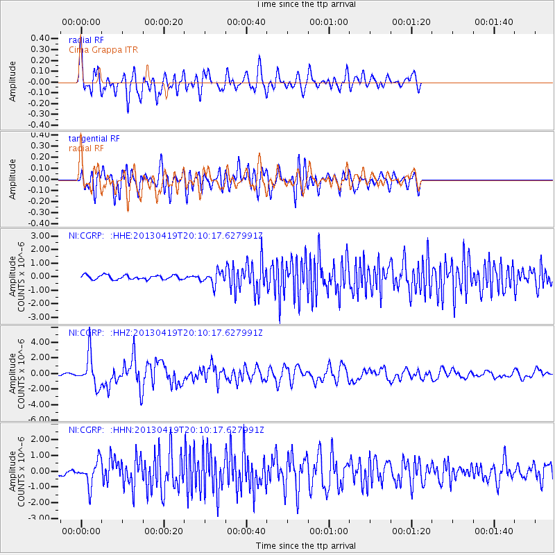
CGRP Cima Grappa - Earthquake Result Viewer
*The percent match for this event was below the threshold and hence no stack was calculated.
| Earthquake location: |
East Of Kuril Islands |
| Earthquake latitude/longitude: |
50.0/157.7 |
| Earthquake time(UTC): |
2013/04/19 (109) 19:58:40 GMT |
| Earthquake Depth: |
15 km |
| Earthquake Magnitude: |
6.1 MW, 5.9 MB, 6.0 MW, 6.1 MS |
| Earthquake Catalog/Contributor: |
NEIC PDE/NEIC PDE-W |
|
| Network: |
NI North-East Italy Broadband Network |
| Station: |
CGRP Cima Grappa |
| Lat/Lon: |
45.88 N/11.80 E |
| Elevation: |
1757 m |
|
| Distance: |
80.0 deg |
| Az: |
336.536 deg |
| Baz: |
21.598 deg |
| Ray Param: |
$rayparam |
*The percent match for this event was below the threshold and hence was not used in the summary stack. |
|
| Radial Match: |
72.912834 % |
| Radial Bump: |
400 |
| Transverse Match: |
60.02364 % |
| Transverse Bump: |
400 |
| SOD ConfigId: |
512894 |
| Insert Time: |
2013-09-13 12:36:50.266 +0000 |
| GWidth: |
2.5 |
| Max Bumps: |
400 |
| Tol: |
0.001 |
|
Signal To Noise
| Channel | StoN | STA | LTA |
| NI:CGRP: :HHZ:20130419T20:10:17.627991Z | 18.45855 | 2.1264525E-6 | 1.15201495E-7 |
| NI:CGRP: :HHN:20130419T20:10:17.627991Z | 3.5088685 | 8.051859E-7 | 2.2947167E-7 |
| NI:CGRP: :HHE:20130419T20:10:17.627991Z | 3.1686265 | 4.8901666E-7 | 1.5433078E-7 |
| Arrivals |
| Ps | |
| PpPs | |
| PsPs/PpSs | |


