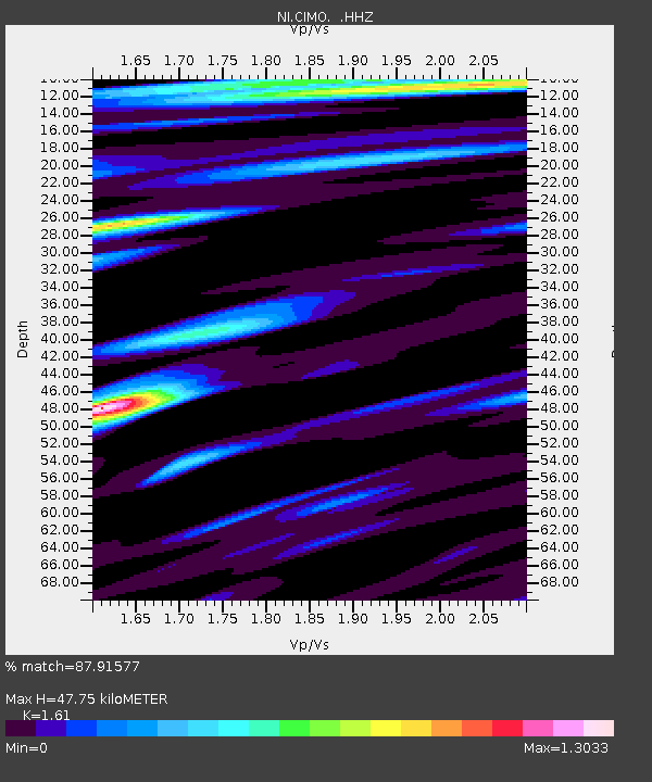
CIMO Cimolais - Earthquake Result Viewer

Earthquake location: East Of Kuril Islands
Earthquake latitude/longitude: 50.0/157.7
Earthquake time(UTC): 2013/04/19 (109) 19:58:40 GMT
Earthquake Depth: 15 km
Earthquake Magnitude: 6.1 MW, 5.9 MB, 6.0 MW, 6.1 MS
Earthquake Catalog/Contributor: NEIC PDE/NEIC PDE-W
Network: NI North-East Italy Broadband Network
Station: CIMO Cimolais
Lat/Lon: 46.31 N/12.44 E
Elevation: 728 m
Distance: 79.5 deg
Az: 336.278 deg
Baz: 22.012 deg
Ray Param: 0.04892881
Estimated Moho Depth: 47.75 km
Estimated Crust Vp/Vs: 1.61
Assumed Crust Vp: 6.35 km/s
Estimated Crust Vs: 3.944 km/s
Estimated Crust Poisson's Ratio: 0.19
Radial Match: 87.91577 %
Radial Bump: 400
Transverse Match: 75.71937 %
Transverse Bump: 400
SOD ConfigId: 512894
Insert Time: 2013-09-13 12:36:51.745 +0000
GWidth: 2.5
Max Bumps: 400
Tol: 0.001

Signal To Noise

ChannelStoNSTALTA
NI:CIMO: :HHZ:20130419T20:10:14.578003Z15.4721591.5304613E-69.891711E-8
NI:CIMO: :HHN:20130419T20:10:14.578003Z3.04597232.784101E-79.14027E-8
NI:CIMO: :HHE:20130419T20:10:14.578003Z4.6423313.518367E-77.57888E-8
Arrivals
Ps4.7 SECOND
PpPs19 SECOND
PsPs/PpSs24 SECOND