You are here: Home > Network List > PE - Penn State Network Stations List
> Station PAGS PA Geological Survey > Earthquake Result Viewer
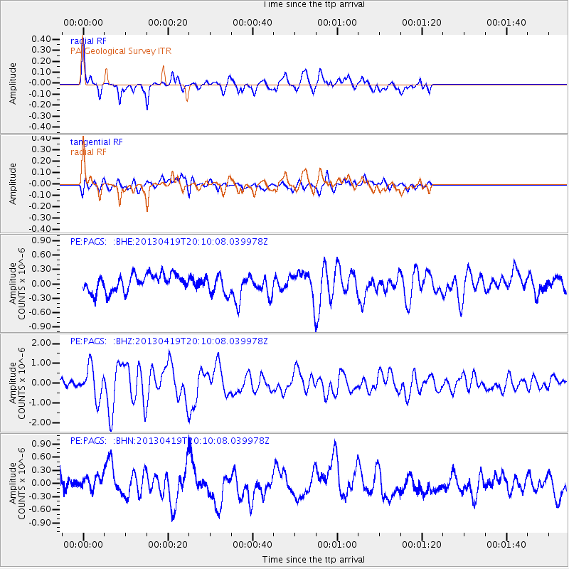
PAGS PA Geological Survey - Earthquake Result Viewer
*The percent match for this event was below the threshold and hence no stack was calculated.
| Earthquake location: |
East Of Kuril Islands |
| Earthquake latitude/longitude: |
50.0/157.7 |
| Earthquake time(UTC): |
2013/04/19 (109) 19:58:40 GMT |
| Earthquake Depth: |
15 km |
| Earthquake Magnitude: |
6.1 MW, 5.9 MB, 6.0 MW, 6.1 MS |
| Earthquake Catalog/Contributor: |
NEIC PDE/NEIC PDE-W |
|
| Network: |
PE Penn State Network |
| Station: |
PAGS PA Geological Survey |
| Lat/Lon: |
40.23 N/76.72 W |
| Elevation: |
120 m |
|
| Distance: |
78.3 deg |
| Az: |
39.463 deg |
| Baz: |
327.581 deg |
| Ray Param: |
$rayparam |
*The percent match for this event was below the threshold and hence was not used in the summary stack. |
|
| Radial Match: |
72.4122 % |
| Radial Bump: |
379 |
| Transverse Match: |
64.535545 % |
| Transverse Bump: |
400 |
| SOD ConfigId: |
512894 |
| Insert Time: |
2013-09-13 12:39:49.545 +0000 |
| GWidth: |
2.5 |
| Max Bumps: |
400 |
| Tol: |
0.001 |
|
Signal To Noise
| Channel | StoN | STA | LTA |
| PE:PAGS: :BHZ:20130419T20:10:08.039978Z | 5.9990144 | 7.9409807E-7 | 1.3237143E-7 |
| PE:PAGS: :BHN:20130419T20:10:08.039978Z | 0.97965974 | 1.923672E-7 | 1.9636124E-7 |
| PE:PAGS: :BHE:20130419T20:10:08.039978Z | 1.191659 | 2.1013193E-7 | 1.7633562E-7 |
| Arrivals |
| Ps | |
| PpPs | |
| PsPs/PpSs | |


