You are here: Home > Network List > TA - USArray Transportable Network (new EarthScope stations) Stations List
> Station D52A ZEK Kipawa Senerzegues Township, QC, CAN > Earthquake Result Viewer
D52A ZEK Kipawa Senerzegues Township, QC, CAN - Earthquake Result Viewer
| Earthquake location: |
East Of Kuril Islands |
| Earthquake latitude/longitude: |
50.0/157.7 |
| Earthquake time(UTC): |
2013/04/19 (109) 19:58:40 GMT |
| Earthquake Depth: |
15 km |
| Earthquake Magnitude: |
6.1 MW, 5.9 MB, 6.0 MW, 6.1 MS |
| Earthquake Catalog/Contributor: |
NEIC PDE/NEIC PDE-W |
|
| Network: |
TA USArray Transportable Network (new EarthScope stations) |
| Station: |
D52A ZEK Kipawa Senerzegues Township, QC, CAN |
| Lat/Lon: |
46.98 N/78.41 W |
| Elevation: |
359 m |
|
| Distance: |
72.0 deg |
| Az: |
36.688 deg |
| Baz: |
325.704 deg |
| Ray Param: |
0.053965017 |
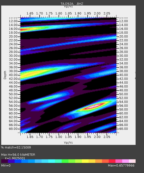
| Estimated Moho Depth: |
56.0 km |
| Estimated Crust Vp/Vs: |
1.98 |
| Assumed Crust Vp: |
6.622 km/s |
| Estimated Crust Vs: |
3.34 km/s |
| Estimated Crust Poisson's Ratio: |
0.33 |
|
| Radial Match: |
82.15089 % |
| Radial Bump: |
400 |
| Transverse Match: |
49.0703 % |
| Transverse Bump: |
400 |
| SOD ConfigId: |
512894 |
| Insert Time: |
2013-09-13 12:46:36.597 +0000 |
| GWidth: |
2.5 |
| Max Bumps: |
400 |
| Tol: |
0.001 |
|
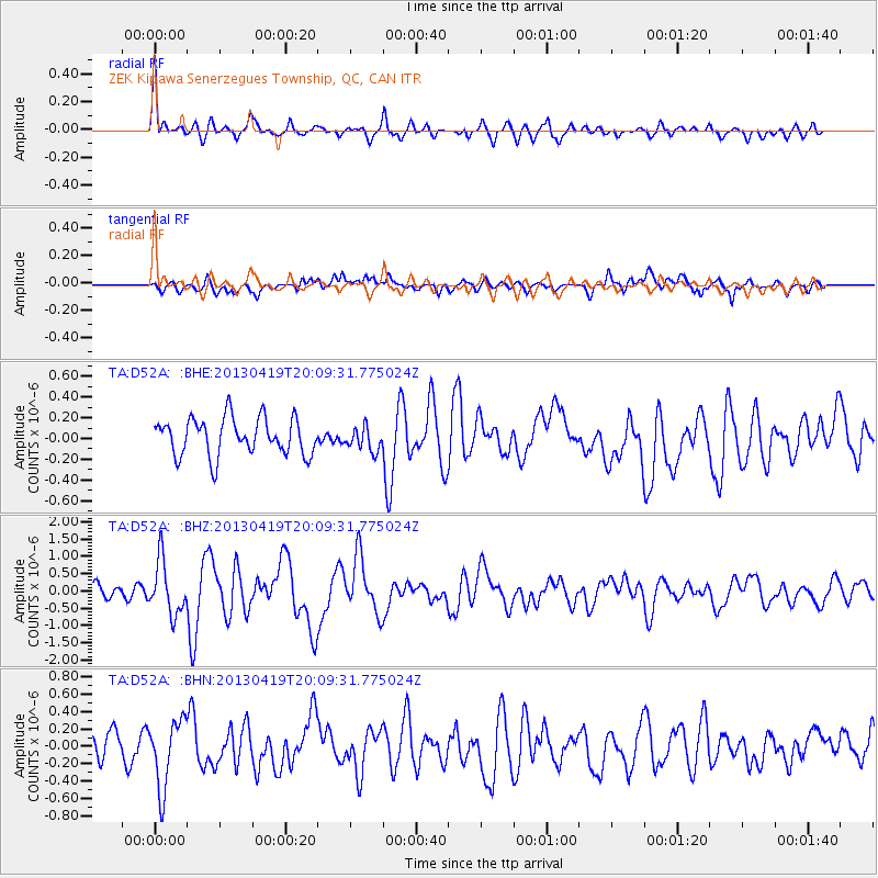
Signal To Noise
| Channel | StoN | STA | LTA |
| TA:D52A: :BHZ:20130419T20:09:31.775024Z | 2.8032854 | 7.6717345E-7 | 2.736694E-7 |
| TA:D52A: :BHN:20130419T20:09:31.775024Z | 2.4425986 | 3.880174E-7 | 1.5885433E-7 |
| TA:D52A: :BHE:20130419T20:09:31.775024Z | 0.62513834 | 1.1263411E-7 | 1.8017471E-7 |
| Arrivals |
| Ps | 8.6 SECOND |
| PpPs | 24 SECOND |
| PsPs/PpSs | 33 SECOND |


