You are here: Home > Network List > TA - USArray Transportable Network (new EarthScope stations) Stations List
> Station E42A Champion, MI, USA > Earthquake Result Viewer
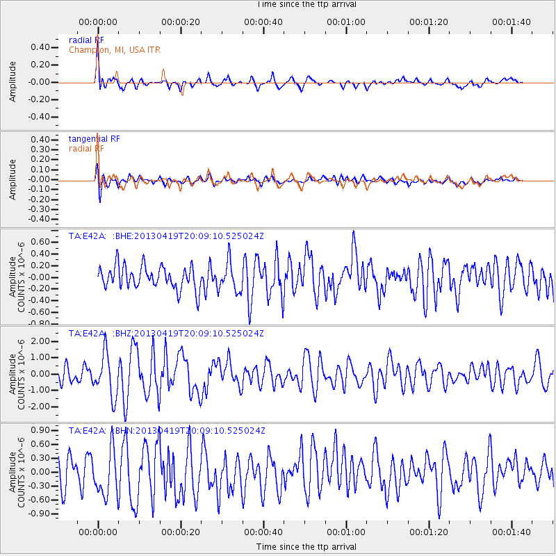
E42A Champion, MI, USA - Earthquake Result Viewer
*The percent match for this event was below the threshold and hence no stack was calculated.
| Earthquake location: |
East Of Kuril Islands |
| Earthquake latitude/longitude: |
50.0/157.7 |
| Earthquake time(UTC): |
2013/04/19 (109) 19:58:40 GMT |
| Earthquake Depth: |
15 km |
| Earthquake Magnitude: |
6.1 MW, 5.9 MB, 6.0 MW, 6.1 MS |
| Earthquake Catalog/Contributor: |
NEIC PDE/NEIC PDE-W |
|
| Network: |
TA USArray Transportable Network (new EarthScope stations) |
| Station: |
E42A Champion, MI, USA |
| Lat/Lon: |
46.43 N/87.91 W |
| Elevation: |
475 m |
|
| Distance: |
68.5 deg |
| Az: |
42.599 deg |
| Baz: |
320.805 deg |
| Ray Param: |
$rayparam |
*The percent match for this event was below the threshold and hence was not used in the summary stack. |
|
| Radial Match: |
78.53161 % |
| Radial Bump: |
400 |
| Transverse Match: |
56.18003 % |
| Transverse Bump: |
400 |
| SOD ConfigId: |
512894 |
| Insert Time: |
2013-09-13 12:47:05.191 +0000 |
| GWidth: |
2.5 |
| Max Bumps: |
400 |
| Tol: |
0.001 |
|
Signal To Noise
| Channel | StoN | STA | LTA |
| TA:E42A: :BHZ:20130419T20:09:10.525024Z | 3.8226829 | 1.3449321E-6 | 3.5182939E-7 |
| TA:E42A: :BHN:20130419T20:09:10.525024Z | 2.060863 | 5.3159636E-7 | 2.5794841E-7 |
| TA:E42A: :BHE:20130419T20:09:10.525024Z | 1.3349886 | 2.576361E-7 | 1.9298747E-7 |
| Arrivals |
| Ps | |
| PpPs | |
| PsPs/PpSs | |


