You are here: Home > Network List > TA - USArray Transportable Network (new EarthScope stations) Stations List
> Station F40A Park Falls, WI, USA > Earthquake Result Viewer
F40A Park Falls, WI, USA - Earthquake Result Viewer
| Earthquake location: |
East Of Kuril Islands |
| Earthquake latitude/longitude: |
50.0/157.7 |
| Earthquake time(UTC): |
2013/04/19 (109) 19:58:40 GMT |
| Earthquake Depth: |
15 km |
| Earthquake Magnitude: |
6.1 MW, 5.9 MB, 6.0 MW, 6.1 MS |
| Earthquake Catalog/Contributor: |
NEIC PDE/NEIC PDE-W |
|
| Network: |
TA USArray Transportable Network (new EarthScope stations) |
| Station: |
F40A Park Falls, WI, USA |
| Lat/Lon: |
45.92 N/90.12 W |
| Elevation: |
486 m |
|
| Distance: |
67.9 deg |
| Az: |
44.222 deg |
| Baz: |
319.82 deg |
| Ray Param: |
0.056642685 |
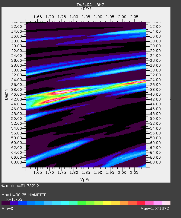
| Estimated Moho Depth: |
38.75 km |
| Estimated Crust Vp/Vs: |
1.75 |
| Assumed Crust Vp: |
6.571 km/s |
| Estimated Crust Vs: |
3.744 km/s |
| Estimated Crust Poisson's Ratio: |
0.26 |
|
| Radial Match: |
81.73212 % |
| Radial Bump: |
400 |
| Transverse Match: |
59.884987 % |
| Transverse Bump: |
400 |
| SOD ConfigId: |
512894 |
| Insert Time: |
2013-09-13 12:48:02.166 +0000 |
| GWidth: |
2.5 |
| Max Bumps: |
400 |
| Tol: |
0.001 |
|

Signal To Noise
| Channel | StoN | STA | LTA |
| TA:F40A: :BHZ:20130419T20:09:06.875Z | 3.531245 | 9.085562E-7 | 2.5729062E-7 |
| TA:F40A: :BHN:20130419T20:09:06.875Z | 1.3627782 | 2.7465097E-7 | 2.0153755E-7 |
| TA:F40A: :BHE:20130419T20:09:06.875Z | 1.2166123 | 1.8713224E-7 | 1.5381418E-7 |
| Arrivals |
| Ps | 4.6 SECOND |
| PpPs | 16 SECOND |
| PsPs/PpSs | 20 SECOND |


