You are here: Home > Network List > TA - USArray Transportable Network (new EarthScope stations) Stations List
> Station L42A Oliver, Polo, IL, USA > Earthquake Result Viewer
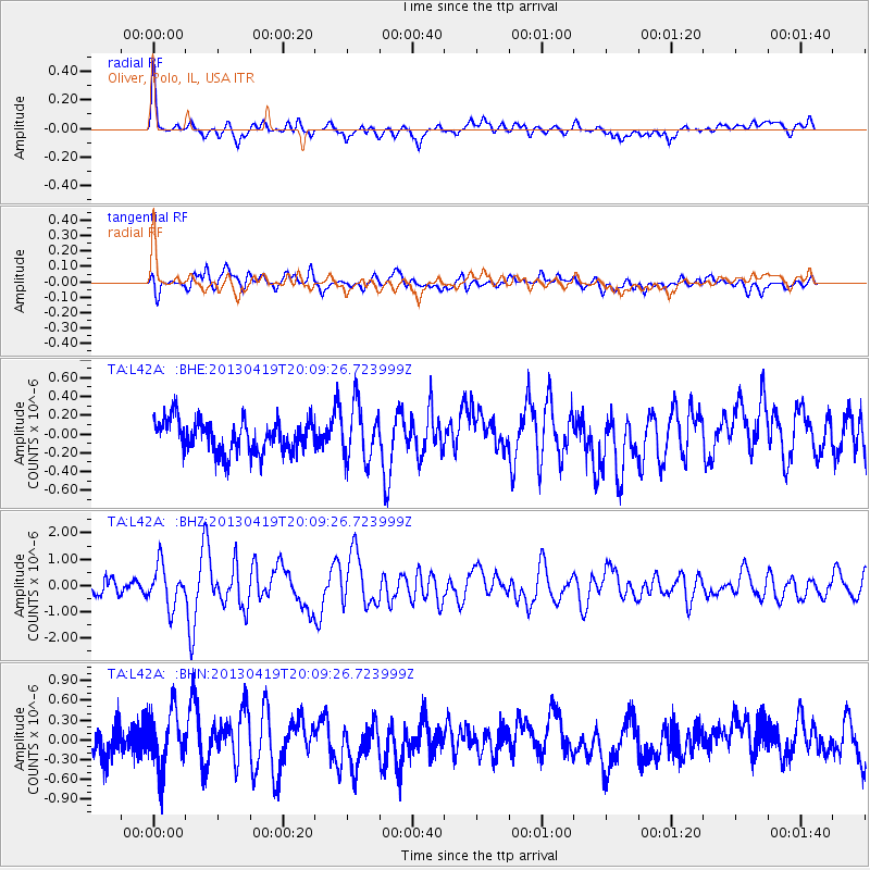
L42A Oliver, Polo, IL, USA - Earthquake Result Viewer
*The percent match for this event was below the threshold and hence no stack was calculated.
| Earthquake location: |
East Of Kuril Islands |
| Earthquake latitude/longitude: |
50.0/157.7 |
| Earthquake time(UTC): |
2013/04/19 (109) 19:58:40 GMT |
| Earthquake Depth: |
15 km |
| Earthquake Magnitude: |
6.1 MW, 5.9 MB, 6.0 MW, 6.1 MS |
| Earthquake Catalog/Contributor: |
NEIC PDE/NEIC PDE-W |
|
| Network: |
TA USArray Transportable Network (new EarthScope stations) |
| Station: |
L42A Oliver, Polo, IL, USA |
| Lat/Lon: |
42.00 N/89.67 W |
| Elevation: |
257 m |
|
| Distance: |
71.1 deg |
| Az: |
46.615 deg |
| Baz: |
320.973 deg |
| Ray Param: |
$rayparam |
*The percent match for this event was below the threshold and hence was not used in the summary stack. |
|
| Radial Match: |
75.499115 % |
| Radial Bump: |
400 |
| Transverse Match: |
46.327 % |
| Transverse Bump: |
400 |
| SOD ConfigId: |
512894 |
| Insert Time: |
2013-09-13 12:53:22.118 +0000 |
| GWidth: |
2.5 |
| Max Bumps: |
400 |
| Tol: |
0.001 |
|
Signal To Noise
| Channel | StoN | STA | LTA |
| TA:L42A: :BHZ:20130419T20:09:26.723999Z | 3.2274342 | 7.625825E-7 | 2.3628135E-7 |
| TA:L42A: :BHN:20130419T20:09:26.723999Z | 1.583829 | 4.3308E-7 | 2.734386E-7 |
| TA:L42A: :BHE:20130419T20:09:26.723999Z | 1.7336898 | 2.9800253E-7 | 1.7188918E-7 |
| Arrivals |
| Ps | |
| PpPs | |
| PsPs/PpSs | |


