You are here: Home > Network List > TA - USArray Transportable Network (new EarthScope stations) Stations List
> Station M53A WI Miller and Sons, Farmdale, OH, USA > Earthquake Result Viewer
M53A WI Miller and Sons, Farmdale, OH, USA - Earthquake Result Viewer

| Earthquake location: |
East Of Kuril Islands |
| Earthquake latitude/longitude: |
50.0/157.7 |
| Earthquake time(UTC): |
2013/04/19 (109) 19:58:40 GMT |
| Earthquake Depth: |
15 km |
| Earthquake Magnitude: |
6.1 MW, 5.9 MB, 6.0 MW, 6.1 MS |
| Earthquake Catalog/Contributor: |
NEIC PDE/NEIC PDE-W |
|
| Network: |
TA USArray Transportable Network (new EarthScope stations) |
| Station: |
M53A WI Miller and Sons, Farmdale, OH, USA |
| Lat/Lon: |
41.44 N/80.68 W |
| Elevation: |
334 m |
|
| Distance: |
75.6 deg |
| Az: |
41.345 deg |
| Baz: |
325.431 deg |
| Ray Param: |
0.051541086 |
| Estimated Moho Depth: |
52.0 km |
| Estimated Crust Vp/Vs: |
1.72 |
| Assumed Crust Vp: |
6.483 km/s |
| Estimated Crust Vs: |
3.78 km/s |
| Estimated Crust Poisson's Ratio: |
0.24 |
|
| Radial Match: |
82.20378 % |
| Radial Bump: |
400 |
| Transverse Match: |
42.83488 % |
| Transverse Bump: |
400 |
| SOD ConfigId: |
512894 |
| Insert Time: |
2013-09-13 12:54:55.480 +0000 |
| GWidth: |
2.5 |
| Max Bumps: |
400 |
| Tol: |
0.001 |
|
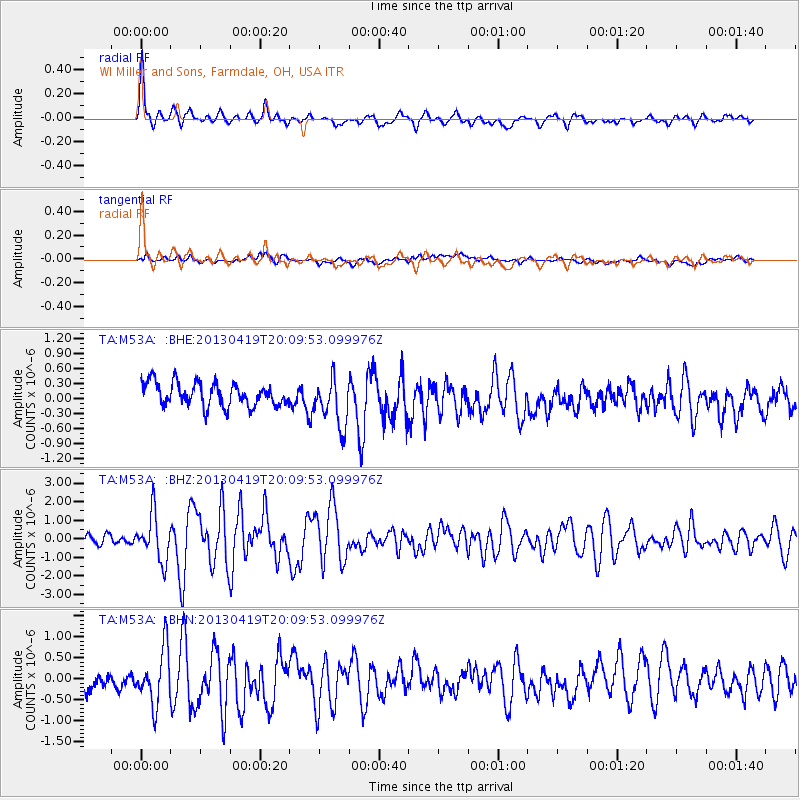
Signal To Noise
| Channel | StoN | STA | LTA |
| TA:M53A: :BHZ:20130419T20:09:53.099976Z | 5.261722 | 1.2438986E-6 | 2.3640521E-7 |
| TA:M53A: :BHN:20130419T20:09:53.099976Z | 3.4419901 | 6.529902E-7 | 1.8971298E-7 |
| TA:M53A: :BHE:20130419T20:09:53.099976Z | 2.0947301 | 4.8594615E-7 | 2.3198508E-7 |
| Arrivals |
| Ps | 5.9 SECOND |
| PpPs | 21 SECOND |
| PsPs/PpSs | 27 SECOND |


