You are here: Home > Network List > TA - USArray Transportable Network (new EarthScope stations) Stations List
> Station MDND Maddock, ND, USA > Earthquake Result Viewer
MDND Maddock, ND, USA - Earthquake Result Viewer
| Earthquake location: |
East Of Kuril Islands |
| Earthquake latitude/longitude: |
50.0/157.7 |
| Earthquake time(UTC): |
2013/04/19 (109) 19:58:40 GMT |
| Earthquake Depth: |
15 km |
| Earthquake Magnitude: |
6.1 MW, 5.9 MB, 6.0 MW, 6.1 MS |
| Earthquake Catalog/Contributor: |
NEIC PDE/NEIC PDE-W |
|
| Network: |
TA USArray Transportable Network (new EarthScope stations) |
| Station: |
MDND Maddock, ND, USA |
| Lat/Lon: |
47.85 N/99.60 W |
| Elevation: |
479 m |
|
| Distance: |
62.1 deg |
| Az: |
48.037 deg |
| Baz: |
314.528 deg |
| Ray Param: |
0.060457688 |
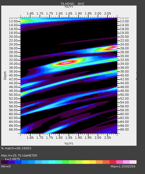
| Estimated Moho Depth: |
25.75 km |
| Estimated Crust Vp/Vs: |
2.10 |
| Assumed Crust Vp: |
6.53 km/s |
| Estimated Crust Vs: |
3.113 km/s |
| Estimated Crust Poisson's Ratio: |
0.35 |
|
| Radial Match: |
88.34003 % |
| Radial Bump: |
326 |
| Transverse Match: |
66.62595 % |
| Transverse Bump: |
388 |
| SOD ConfigId: |
512894 |
| Insert Time: |
2013-09-13 12:55:10.129 +0000 |
| GWidth: |
2.5 |
| Max Bumps: |
400 |
| Tol: |
0.001 |
|

Signal To Noise
| Channel | StoN | STA | LTA |
| TA:MDND: :BHZ:20130419T20:08:29.025024Z | 8.286052 | 1.1839815E-6 | 1.4288848E-7 |
| TA:MDND: :BHN:20130419T20:08:29.025024Z | 1.1542085 | 3.753846E-7 | 3.2523116E-7 |
| TA:MDND: :BHE:20130419T20:08:29.025024Z | 0.79840344 | 4.045307E-7 | 5.0667455E-7 |
| Arrivals |
| Ps | 4.5 SECOND |
| PpPs | 12 SECOND |
| PsPs/PpSs | 16 SECOND |


