You are here: Home > Network List > TA - USArray Transportable Network (new EarthScope stations) Stations List
> Station N45A Kentland, IN, USA > Earthquake Result Viewer
N45A Kentland, IN, USA - Earthquake Result Viewer
| Earthquake location: |
East Of Kuril Islands |
| Earthquake latitude/longitude: |
50.0/157.7 |
| Earthquake time(UTC): |
2013/04/19 (109) 19:58:40 GMT |
| Earthquake Depth: |
15 km |
| Earthquake Magnitude: |
6.1 MW, 5.9 MB, 6.0 MW, 6.1 MS |
| Earthquake Catalog/Contributor: |
NEIC PDE/NEIC PDE-W |
|
| Network: |
TA USArray Transportable Network (new EarthScope stations) |
| Station: |
N45A Kentland, IN, USA |
| Lat/Lon: |
40.85 N/87.51 W |
| Elevation: |
206 m |
|
| Distance: |
73.0 deg |
| Az: |
46.034 deg |
| Baz: |
322.215 deg |
| Ray Param: |
0.05325527 |
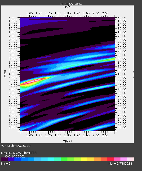
| Estimated Moho Depth: |
43.25 km |
| Estimated Crust Vp/Vs: |
1.68 |
| Assumed Crust Vp: |
6.498 km/s |
| Estimated Crust Vs: |
3.879 km/s |
| Estimated Crust Poisson's Ratio: |
0.22 |
|
| Radial Match: |
80.15782 % |
| Radial Bump: |
400 |
| Transverse Match: |
56.118755 % |
| Transverse Bump: |
400 |
| SOD ConfigId: |
512894 |
| Insert Time: |
2013-09-13 12:55:32.233 +0000 |
| GWidth: |
2.5 |
| Max Bumps: |
400 |
| Tol: |
0.001 |
|
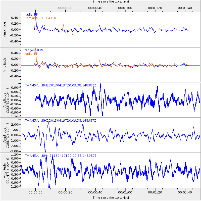
Signal To Noise
| Channel | StoN | STA | LTA |
| TA:N45A: :BHZ:20130419T20:09:38.148987Z | 4.0241027 | 9.775188E-7 | 2.4291595E-7 |
| TA:N45A: :BHN:20130419T20:09:38.148987Z | 2.516509 | 5.1389605E-7 | 2.042099E-7 |
| TA:N45A: :BHE:20130419T20:09:38.148987Z | 1.5238165 | 3.471249E-7 | 2.2779969E-7 |
| Arrivals |
| Ps | 4.7 SECOND |
| PpPs | 17 SECOND |
| PsPs/PpSs | 22 SECOND |


