You are here: Home > Network List > TA - USArray Transportable Network (new EarthScope stations) Stations List
> Station N55A Marion Center, PA, USA > Earthquake Result Viewer
N55A Marion Center, PA, USA - Earthquake Result Viewer
| Earthquake location: |
East Of Kuril Islands |
| Earthquake latitude/longitude: |
50.0/157.7 |
| Earthquake time(UTC): |
2013/04/19 (109) 19:58:40 GMT |
| Earthquake Depth: |
15 km |
| Earthquake Magnitude: |
6.1 MW, 5.9 MB, 6.0 MW, 6.1 MS |
| Earthquake Catalog/Contributor: |
NEIC PDE/NEIC PDE-W |
|
| Network: |
TA USArray Transportable Network (new EarthScope stations) |
| Station: |
N55A Marion Center, PA, USA |
| Lat/Lon: |
40.78 N/78.99 W |
| Elevation: |
559 m |
|
| Distance: |
76.9 deg |
| Az: |
40.637 deg |
| Baz: |
326.369 deg |
| Ray Param: |
0.05069237 |
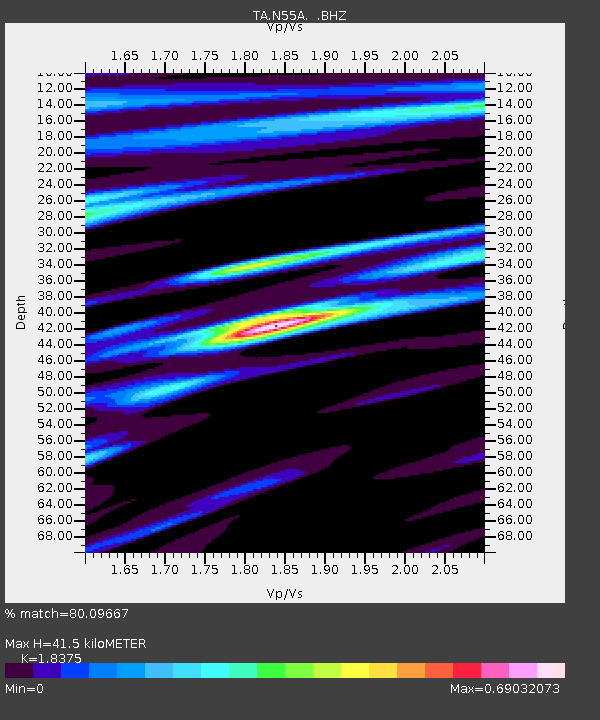
| Estimated Moho Depth: |
41.5 km |
| Estimated Crust Vp/Vs: |
1.84 |
| Assumed Crust Vp: |
6.121 km/s |
| Estimated Crust Vs: |
3.331 km/s |
| Estimated Crust Poisson's Ratio: |
0.29 |
|
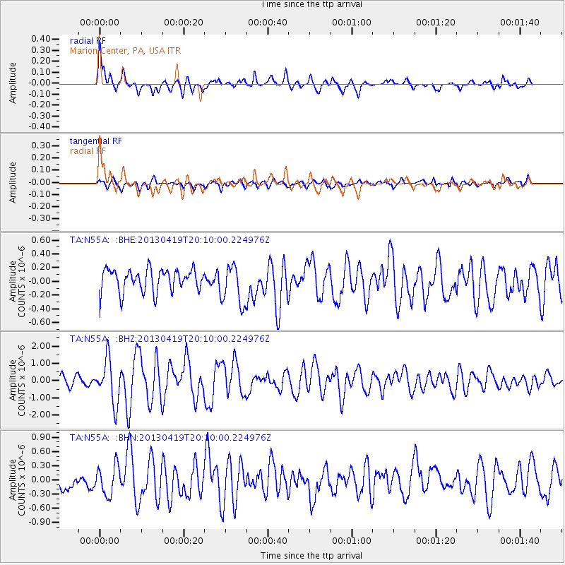
| Radial Match: |
80.09667 % |
| Radial Bump: |
368 |
| Transverse Match: |
61.9 % |
| Transverse Bump: |
400 |
| SOD ConfigId: |
512894 |
| Insert Time: |
2013-09-13 12:56:08.637 +0000 |
| GWidth: |
2.5 |
| Max Bumps: |
400 |
| Tol: |
0.001 |
|
Signal To Noise
| Channel | StoN | STA | LTA |
| TA:N55A: :BHZ:20130419T20:10:00.224976Z | 4.505582 | 1.3087041E-6 | 2.9046285E-7 |
| TA:N55A: :BHN:20130419T20:10:00.224976Z | 1.9566714 | 3.1956046E-7 | 1.6331842E-7 |
| TA:N55A: :BHE:20130419T20:10:00.224976Z | 1.7812945 | 2.9430714E-7 | 1.6522095E-7 |
| Arrivals |
| Ps | 5.8 SECOND |
| PpPs | 19 SECOND |
| PsPs/PpSs | 25 SECOND |


