You are here: Home > Network List > TA - USArray Transportable Network (new EarthScope stations) Stations List
> Station O50A Cable, OH, USA > Earthquake Result Viewer
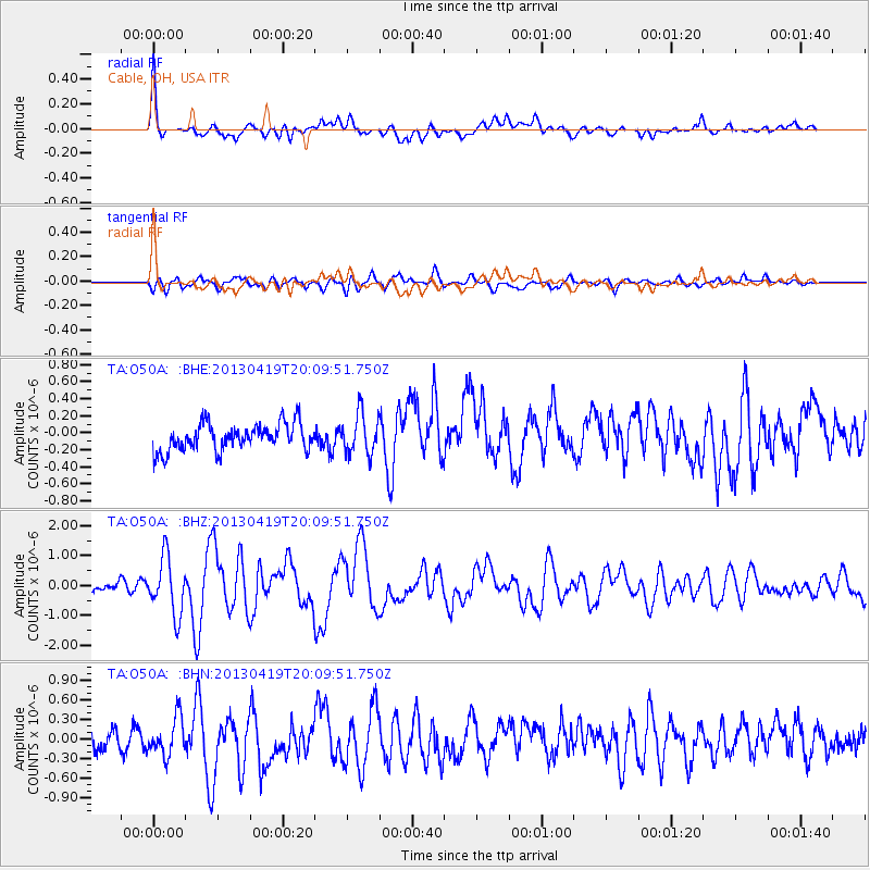
O50A Cable, OH, USA - Earthquake Result Viewer
*The percent match for this event was below the threshold and hence no stack was calculated.
| Earthquake location: |
East Of Kuril Islands |
| Earthquake latitude/longitude: |
50.0/157.7 |
| Earthquake time(UTC): |
2013/04/19 (109) 19:58:40 GMT |
| Earthquake Depth: |
15 km |
| Earthquake Magnitude: |
6.1 MW, 5.9 MB, 6.0 MW, 6.1 MS |
| Earthquake Catalog/Contributor: |
NEIC PDE/NEIC PDE-W |
|
| Network: |
TA USArray Transportable Network (new EarthScope stations) |
| Station: |
O50A Cable, OH, USA |
| Lat/Lon: |
40.15 N/83.62 W |
| Elevation: |
399 m |
|
| Distance: |
75.4 deg |
| Az: |
44.001 deg |
| Baz: |
324.18 deg |
| Ray Param: |
$rayparam |
*The percent match for this event was below the threshold and hence was not used in the summary stack. |
|
| Radial Match: |
76.21 % |
| Radial Bump: |
400 |
| Transverse Match: |
62.52952 % |
| Transverse Bump: |
400 |
| SOD ConfigId: |
512894 |
| Insert Time: |
2013-09-13 12:56:47.640 +0000 |
| GWidth: |
2.5 |
| Max Bumps: |
400 |
| Tol: |
0.001 |
|
Signal To Noise
| Channel | StoN | STA | LTA |
| TA:O50A: :BHZ:20130419T20:09:51.750Z | 4.918022 | 9.3679444E-7 | 1.9048194E-7 |
| TA:O50A: :BHN:20130419T20:09:51.750Z | 1.997717 | 2.8776722E-7 | 1.4404803E-7 |
| TA:O50A: :BHE:20130419T20:09:51.750Z | 1.4906136 | 2.3511272E-7 | 1.5772882E-7 |
| Arrivals |
| Ps | |
| PpPs | |
| PsPs/PpSs | |


