You are here: Home > Network List > TA - USArray Transportable Network (new EarthScope stations) Stations List
> Station Q49A Aurora, IN, USA > Earthquake Result Viewer
Q49A Aurora, IN, USA - Earthquake Result Viewer
| Earthquake location: |
East Of Kuril Islands |
| Earthquake latitude/longitude: |
50.0/157.7 |
| Earthquake time(UTC): |
2013/04/19 (109) 19:58:40 GMT |
| Earthquake Depth: |
15 km |
| Earthquake Magnitude: |
6.1 MW, 5.9 MB, 6.0 MW, 6.1 MS |
| Earthquake Catalog/Contributor: |
NEIC PDE/NEIC PDE-W |
|
| Network: |
TA USArray Transportable Network (new EarthScope stations) |
| Station: |
Q49A Aurora, IN, USA |
| Lat/Lon: |
39.01 N/84.90 W |
| Elevation: |
264 m |
|
| Distance: |
75.7 deg |
| Az: |
45.517 deg |
| Baz: |
323.748 deg |
| Ray Param: |
0.05146791 |
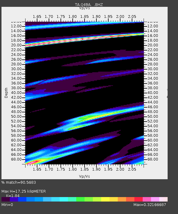
| Estimated Moho Depth: |
17.25 km |
| Estimated Crust Vp/Vs: |
1.84 |
| Assumed Crust Vp: |
6.498 km/s |
| Estimated Crust Vs: |
3.531 km/s |
| Estimated Crust Poisson's Ratio: |
0.29 |
|
| Radial Match: |
90.5683 % |
| Radial Bump: |
255 |
| Transverse Match: |
69.48296 % |
| Transverse Bump: |
400 |
| SOD ConfigId: |
512894 |
| Insert Time: |
2013-09-13 12:58:16.907 +0000 |
| GWidth: |
2.5 |
| Max Bumps: |
400 |
| Tol: |
0.001 |
|

Signal To Noise
| Channel | StoN | STA | LTA |
| TA:Q49A: :BHZ:20130419T20:09:53.700012Z | 7.4584394 | 1.1878554E-6 | 1.5926328E-7 |
| TA:Q49A: :BHN:20130419T20:09:53.700012Z | 4.072917 | 4.400509E-7 | 1.08043174E-7 |
| TA:Q49A: :BHE:20130419T20:09:53.700012Z | 3.0505326 | 3.4757326E-7 | 1.13938555E-7 |
| Arrivals |
| Ps | 2.3 SECOND |
| PpPs | 7.3 SECOND |
| PsPs/PpSs | 9.6 SECOND |


