You are here: Home > Network List > TA - USArray Transportable Network (new EarthScope stations) Stations List
> Station R48A Northridge Ranch, Floyd Knobs, IN, USA > Earthquake Result Viewer
R48A Northridge Ranch, Floyd Knobs, IN, USA - Earthquake Result Viewer

| Earthquake location: |
East Of Kuril Islands |
| Earthquake latitude/longitude: |
50.0/157.7 |
| Earthquake time(UTC): |
2013/04/19 (109) 19:58:40 GMT |
| Earthquake Depth: |
15 km |
| Earthquake Magnitude: |
6.1 MW, 5.9 MB, 6.0 MW, 6.1 MS |
| Earthquake Catalog/Contributor: |
NEIC PDE/NEIC PDE-W |
|
| Network: |
TA USArray Transportable Network (new EarthScope stations) |
| Station: |
R48A Northridge Ranch, Floyd Knobs, IN, USA |
| Lat/Lon: |
38.40 N/85.87 W |
| Elevation: |
243 m |
|
| Distance: |
75.8 deg |
| Az: |
46.521 deg |
| Baz: |
323.388 deg |
| Ray Param: |
0.051445935 |
| Estimated Moho Depth: |
69.5 km |
| Estimated Crust Vp/Vs: |
1.94 |
| Assumed Crust Vp: |
6.498 km/s |
| Estimated Crust Vs: |
3.354 km/s |
| Estimated Crust Poisson's Ratio: |
0.32 |
|
| Radial Match: |
83.04738 % |
| Radial Bump: |
400 |
| Transverse Match: |
73.39823 % |
| Transverse Bump: |
400 |
| SOD ConfigId: |
512894 |
| Insert Time: |
2013-09-13 12:59:03.987 +0000 |
| GWidth: |
2.5 |
| Max Bumps: |
400 |
| Tol: |
0.001 |
|
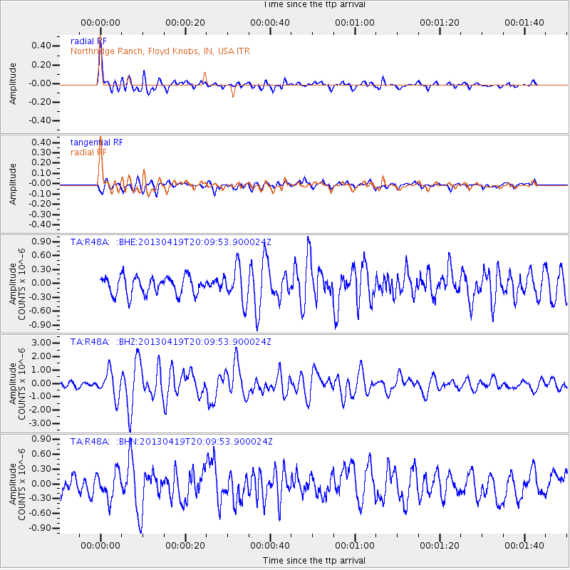
Signal To Noise
| Channel | StoN | STA | LTA |
| TA:R48A: :BHZ:20130419T20:09:53.900024Z | 6.659233 | 9.847462E-7 | 1.4787682E-7 |
| TA:R48A: :BHN:20130419T20:09:53.900024Z | 1.5719912 | 2.767153E-7 | 1.7602852E-7 |
| TA:R48A: :BHE:20130419T20:09:53.900024Z | 2.0086088 | 3.833109E-7 | 1.9083403E-7 |
| Arrivals |
| Ps | 10 SECOND |
| PpPs | 30 SECOND |
| PsPs/PpSs | 41 SECOND |


